


Hey guys, here’s this week’s edition of the Spatial Edge — a newsletter that’s as anticipated as The Odyssey. The aim, as usual, is to make you a better geospatial data scientist in less than five minutes a week.
In today’s newsletter:
Fine-Grained Damage Assessment: Drone AI improves post-disaster mapping.
Remote Sensing Agents: RS-Claw streamlines AI tool selection.
Cross-Border Generalisation: Foundation models struggle across countries.
Night-Time Dataset: Sentinel-2 releases high-res nighttime imagery.
Research you should know about
1. Fine-grained damage assessment from drone imagery

Rapid and accurate damage assessment is pretty important after natural disasters, but manual field surveys are often too slow or can be too dangerous to conduct. So automated semantic segmentation models offer a faster alternative, yet they frequently struggle to provide the fine-grained detail required for effective emergency response. When researchers feed high-resolution drone imagery into these models, they typically downsample the images to fit into memory, which actually has the effect of destroying subtle textures that distinguish minor roof damage from major structural collapse. Furthermore, the datasets are heavily imbalanced, with vast amounts of background scenery and very few examples of critically damaged buildings, which often causes standard models to ignore these rare but important hazards.
DA-SegFormer, an adaptation of the SegFormer architecture, is specifically tuned to extract disaster data from high-resolution drone imagery. Instead of aggressive downsampling, the authors use a resolution-preserving protocol where the model processes images in sliding windows, keeping native details intact so it can accurately identify fine-grained damage. To combat the severe class imbalance, they introduced a sampling strategy that forces the model to focus on rare damage cases. They also combined Online Hard Example Mining with Dice Loss, which effectively forces the network to concentrate on the visually subtle decision boundaries between different levels of damage rather than just the easy-to-identify background.
The model shows real promise for emergency responders, as it outperformed the baseline on the RescueNet benchmark with a 74.61% mean intersection over union. Interestingly, it delivered double-digit gains for critical damage classes, identifying minor and major damage far more accurately than standard models. These granular improvements allow for much more reliable automated assessments that help responders allocate help where it is needed most.
2. OpenClaw for Remote Sensing
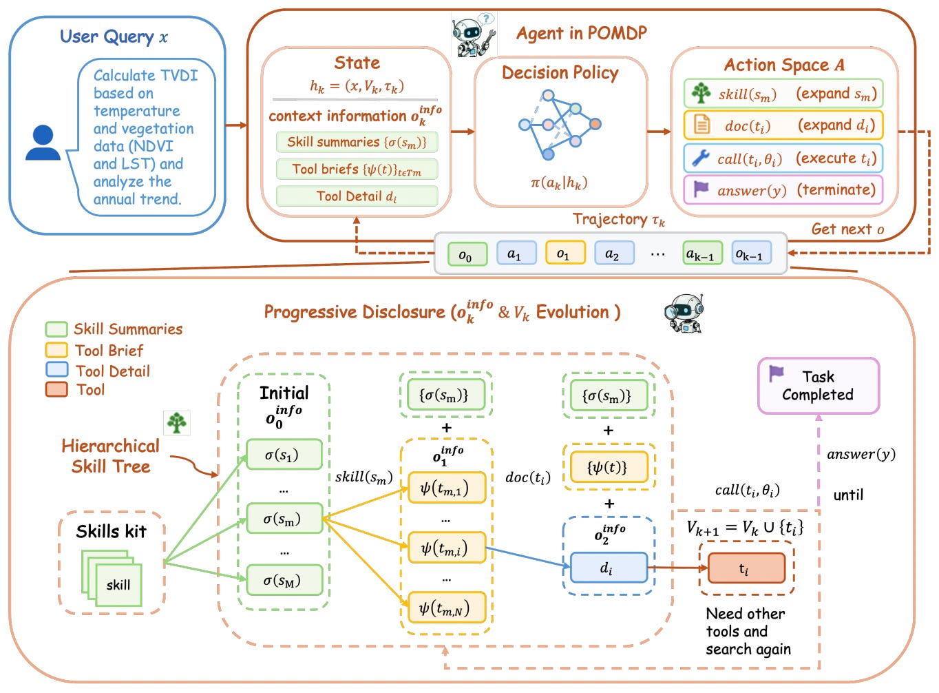
If you go on X these days, you’re going to be drowning in all the chatter about AI agents. And it’s no surprise that the remote sensing community is also looking at agents. One of the ongoing problems though, is how these agents select their tools. Most current setups just dump the entire list of available tools into the system prompt. Since the remote sensing tool ecosystem is massive, this leads to context bloat and can oftentimes lead to the agent choosing the wrong tool. It creates a major trade-off where agents either struggle to fit everything in their memory or end up omitting critical tools entirely, as they are essentially passive recipients of a flat, static list.
To solve this, researchers introduce RS-Claw. Rather than being passive recipients of a static tool list, RS-Claw agents navigate a hierarchical skill tree. The model essentially discovers and loads tools on demand, moving from a high-level skill summary down to detailed execution documents only when necessary. This progressive disclosure approach keeps the reasoning space clean and free of semantic noise. When tested on the Earth-Bench benchmark, RS-Claw outperformed existing passive baselines across various reasoning tasks, successfully filtering out irrelevant information while slashing input token requirements by up to 86%.
The results show that treating tool acquisition as a dynamic process rather than a static setup significantly improves agent reliability in complex, long-horizon tasks. This is a pretty big shift for geospatial AI, as it allows for much larger, more diverse tool libraries to be used effectively without overwhelming the model.
3. Do foundation models really generalise across borders?

Researchers often hope that foundation models trained on massive satellite archives will provide universal visual features that work anywhere in the world. A new study puts this to the test by using a Leave-One-Country-Out evaluation protocol to see if these models can accurately predict smallholder maize yields across different countries in sub-Saharan Africa. By training models in four countries and testing them on a fifth, the author aimed to find out if geospatial foundation models, like IBM and NASA’s Prithvi-EO, could overcome the usual struggles of cross-country yield transfer.
The results were pretty interesting. While models performed reasonably well when tested on data from the same country, they completely collapsed when asked to predict yields in a new, unseen country, often performing worse than a naive baseline that simply predicts the training set average. Surprisingly, the frozen embeddings from the Prithvi foundation model didn’t provide any meaningful advantage over a standard set of 10-band spectral medians. The author argues that this isn’t necessarily a failure of the foundation models themselves, but rather a reflection of fundamental data distribution shifts in yield across different national contexts that satellite imagery alone cannot easily bridge.
This study serves as a necessary reality check for the field, demonstrating that geospatial pre-training alone can’t close the generalisation gap when yield statistics vary wildly between regions. It establishes a clear, reproducible negative benchmark that should push future research toward more robust domain adaptation and meta-learning techniques.
Geospatial Datasets
1. Sentinel-2 night-time campaign dataset
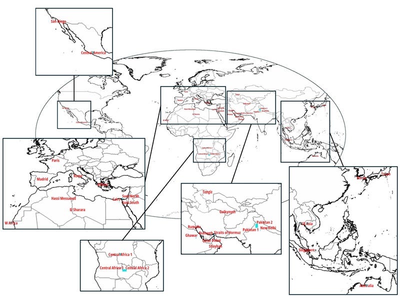
The Sentinel-2 night-time campaign dataset provides a collection of 56 night-time satellite acquisitions captured during a dedicated observation campaign in December 2025. You can access the data here.
2. Southeast Asian high-resolution climate dataset
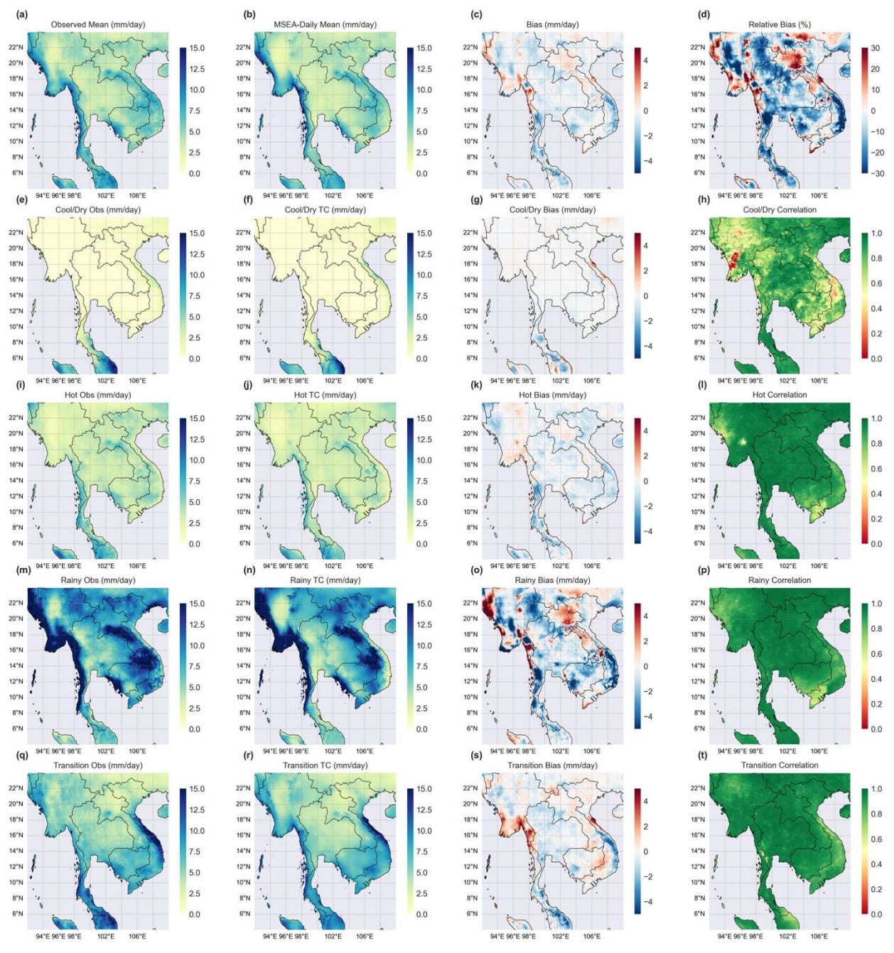
The MSEA-Daily dataset provides a high-resolution, gridded daily climate inventory at a 4-km 1/24° spatial scale for mainland Southeast Asia, covering Myanmar, Thailand, Laos, Cambodia, and Vietnam from 1981 to 2014. You can access the data here and the code here.
3. Climate Data Store expanded dataset
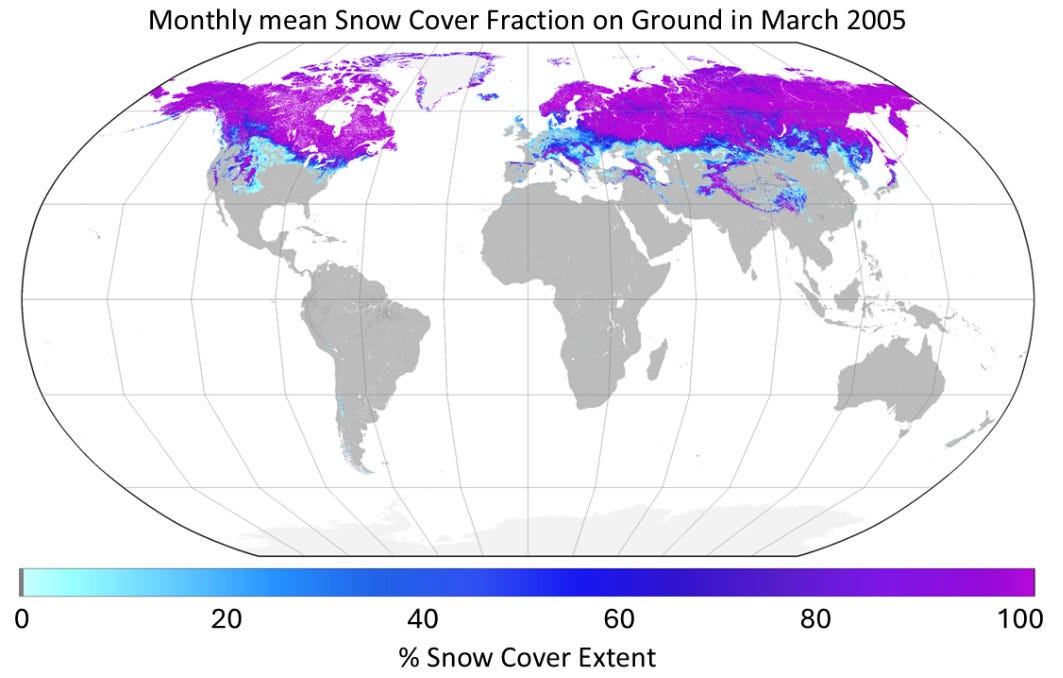
The Copernicus Climate Change Service (C3S) has expanded its Climate Data Store (CDS) with a bunch of new open-access climate records and sectoral indicators spanning the atmosphere, land, ocean, cryosphere, and water cycle. You can access CDS here.
4. Cross-platform flood detection dataset

The Sen2GF3Floods dataset provides a multi-source flood mapping resource consisting of 21,483 standardised 10-m resolution image patches (256 × 256 pixels) covering nine major global flood events. You can access the data here and the code here.
Other useful bits
Google Research found that in 10 major US cities, systematically rerouting under 2% of navigation app users away from bottlenecks can measurably improve traffic speeds and reduce carbon emissions for all road users. By dispersing traffic across underutilised peripheral roads, this is a scalable approach to enhancing network-wide efficiency and urban sustainability.
Planet Labs is advancing its "Planetary Intelligence" initiative by embedding AI across its satellite hardware, data processing, and user applications to deliver near-real-time Earth observation insights. By integrating edge compute into satellites, sharpening image resolution via AI, and testing a natural-language mapping agent, the company aims to make complex global monitoring accessible to non-technical users.
European Southern Observatory says that surpassing 100,000 satellites in orbit could render ground-based telescopes obsolete by causing irreversible light pollution and image corruption. The research notes that proposed megaconstellations, including thousands of highly reflective orbital mirrors, threaten to brighten the night sky by up to 300% and permanently disrupt global astronomical observations.
Jobs
Esri Netherlands is looking for an Analytics Consultant based in Rotterdam.
UNOPS is looking for an ICT Officer based in Valencia.
UNDP is looking for a Spatial Planning and GIS Expert based in Malaysia.
ESA is accepting applications for their mid-year internship opportunities under:
Just for Fun
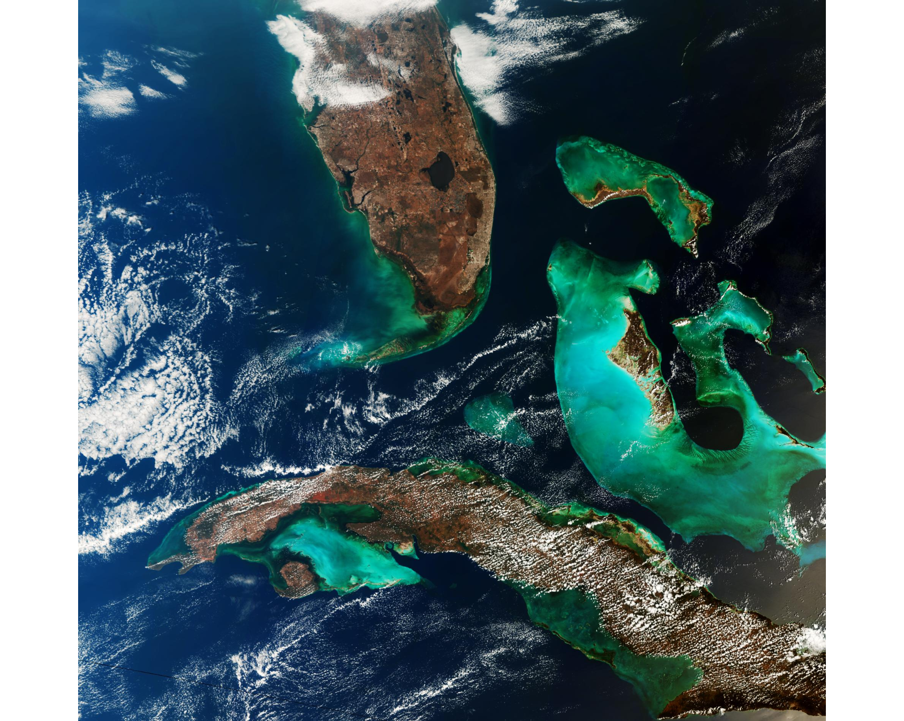
ESA has marked the 1000th image of its "Earth from Space" series with a Copernicus Sentinel-3 satellite capture of Florida, Cuba, and the Bahamas, returning to the exact region featured in the programme's inaugural 2004 edition.
That’s it for this week.
I’m always keen to hear from you, so please let me know if you have:
new geospatial datasets
newly published papers
geospatial job opportunities
and I’ll do my best to showcase them here.
Yohan
Thanks for this newsletter, it’s so useful!