

How natural disasters reduce educational outcomes
PLUS: A foundation model for mineral prospecting, how 'cool pavements' are reducing temperatures, and a new large-scale weather station dataset

Hey guys, here’s this week’s edition of Spatial Edge — a weekly round-up of geospatial news. The goal is to help make you the Beyoncé of geospatial data science in less than 5 minutes a week.
In today’s newsletter:
Natural Disasters and Education: Disasters reduce long-term learning gains.
Mineral Prospecting: Model identifies mineral deposits using geospatial data.
Cool Pavements: Reflective pavements lower urban surface temperatures.
Socioeconomic Outcomes from Satellite Data: Vegetation, housing density affect income, liveability.
Transformers in Remote Sensing: Improved scene classification and image analysis.
Research you should know about
1. How natural disasters impact education and human capital

Researchers from RAND, Wharton and Amazon, have found that natural disasters don’t just impact physical capital — they also impact educational outcomes.
Using geospatial data on natural disasters from SHELDUS, and education data from SEDA, they find natural disasters reduce learning gains. They also find that the larger the natural disaster, the bigger the impact is.
For disasters causing more than $500 in damages per person, the estimated loss in future earnings and education value is about $268 per person.
2. Geospatial Foundation Models for Mineral Prospecting

A new paper funded by RAND has put forward the ‘first step’ towards a foundation model used for mineral prospecting. ‘What the heck is a foundation model?’, I hear you ask. Luckily I’ve got you covered.
Minerals are critical for the transition to sustainable energy — they’re used in manufacturing solar panels, batteries, and so on. The dream of many companies is to use an off-the-shelf solution to identify mineral deposits using geospatial data.
This paper uses a bunch of datasets such as:
magnetic anomalies: variations in the Earth’s magnetic field
gravity data: variations in Earth’s gravity
lithology: physical characteristics of rock layers
geological age of rock formations
digital elevation
seismic data
satellite data
They used an encoder-decoder with a Vision Transformer as the encoder. Their methodology provided significant improvements to other models (e.g. CNNs, Gradient Boosting, etc.).
3. ‘Cool pavements’ as a way of reducing air temperatures in urban areas
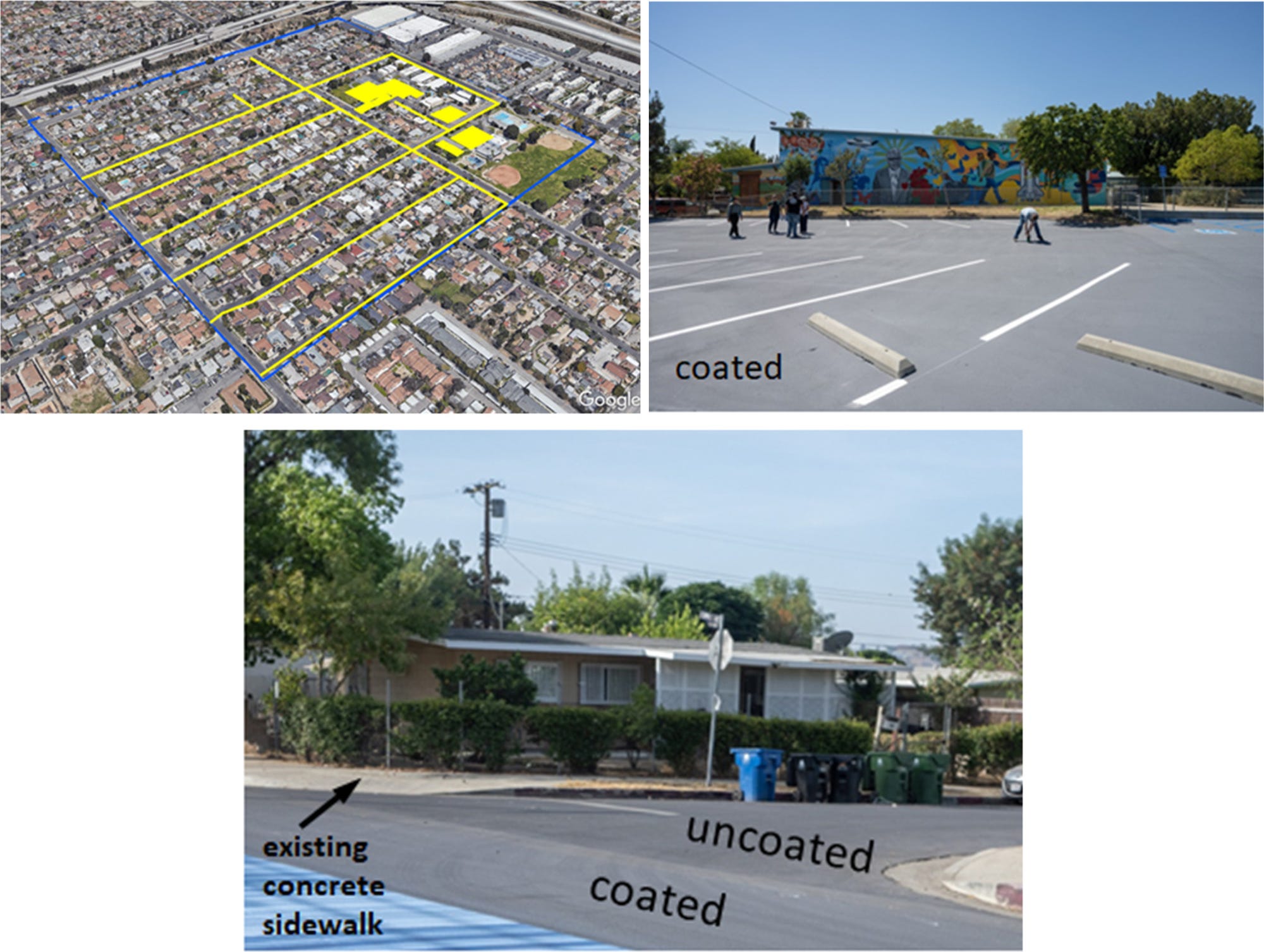
A new study examines the impact of reflective pavements on reducing temperatures in urban areas. I’ve previously discussed inequalities in exposure to high temperatures (and heat-related deaths).
However, one potential solution is using reflective coatings on roads and pavements. In the study, a total of 59,570 square meters of pavement was coated, representing 23% of the test community's area. The reflective surfaces included streets, parking lots, and other paved areas.
To measure the impact of reflective pavements on temperature, the studies used:
satellites (MODIS and Landsat-9),
thermal imaging from aircraft flyovers,
drones, and
weather stations
They found that, due to reflective pavements, mean surface temperatures in the afternoon reduced by 2.6°C−4.9°C (or 36.68°F − 40.82°F for you imperial folks).
4. Using satellite data to measure socioeconomic outcomes in cities
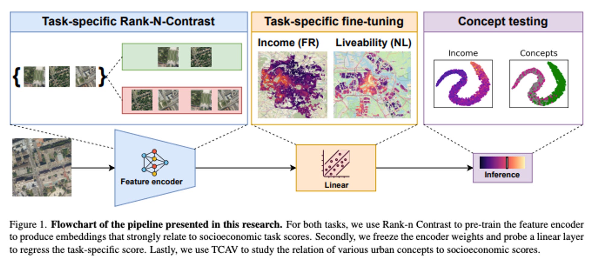
New research explores how combining representation learning (a technique where the model learns to identify important features in the data) with a method called ‘task-specific contrastive loss’ (i.e. a way to compare and learn from related data) enhances our understanding of socioeconomic data
They find that this technique organizes data in a way that reflects socioeconomic outcomes more clearly. The model essentially sorts these features in a way that reflects the progression of socioeconomic conditions, making it easier to understand how different patterns relate to different levels of socioeconomic indicators.
Key urban planning insights include:
Vegetation: Higher-income and more liveable areas benefit from more green spaces.
Residential Density: Different housing densities show clear patterns in relation to socioeconomic outcomes.
The model is trained on aerial images paired with income data from France and liveability scores from the Netherlands.
5. Assessing the usefulness of transformers in remote sensing
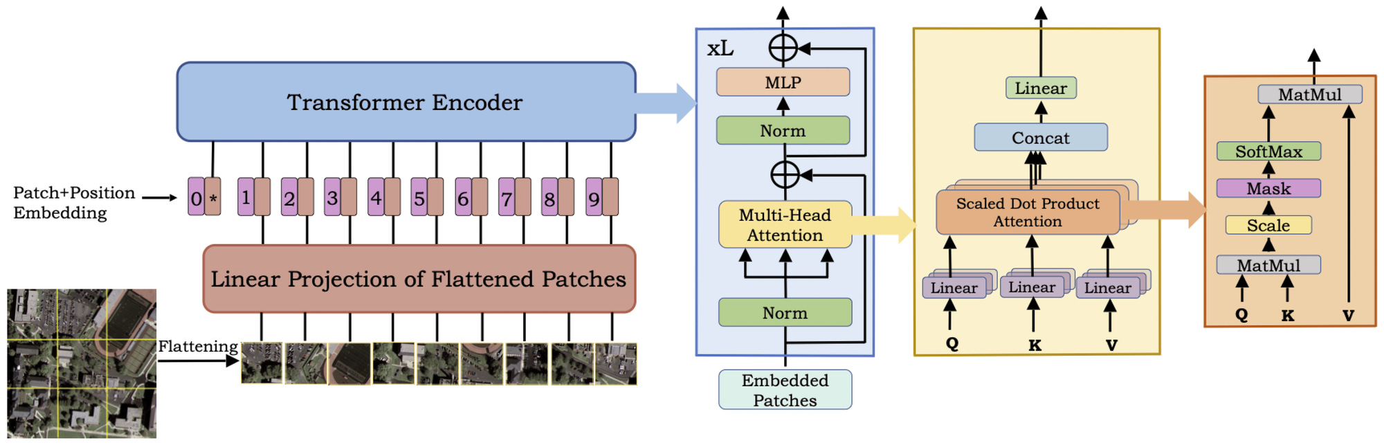
A new study surveys the usefulness of vision transformers (ViTs) in remote sensing applications.
Transformers are a popular deep-learning algorithm, associated with large language models. However, they’re being increasingly used in remote sensing applications.
Here are the key findings:
Transformers in very high-res (VHR) imagery are able to show improvements in:
Scene classification (when combined with CNNs)
Image change detection
Image segmentation (when combining CNN’s local feature extraction with transformer’s global context)
Transformers in hyperspectral images show improvements in:
Image classification
Pansharpening
Transformers in SAR imagery show improvements in:
Image interpretation and classification
Segmentation and detection
Despeckling and change detection
Geospatial Datasets
1. WEATHER-5K: A Large-scale Global Station Weather Dataset Towards Comprehensive Time-series Forecasting Benchmark

Weather-5K aggregates data from 5,672 weather stations worldwide spanning 10 years with one-hour intervals. It can be used for researchers involved in time-series forecasting of weather conditions, as the data can be used to train and evaluate models.
Time Frame: Spanning a 10-year period with one-hour intervals.
Content: Includes multiple crucial weather elements, making it a comprehensive resource for forecasting.
2. FT-AED: Benchmark Dataset for Early Freeway Traffic Anomalous Event Detection
A new dataset provides the first large-scale, lane-level freeway traffic dataset specifically designed for anomaly detection. It’s focussed on one month of data for Nashville and includes over 3.7m radar sensor measurements across 4 lanes of freeway.
Other interesting bits

ACLED and WorldPop have developed a tool to show how many people are affected by armed conflict.** They measure the number of people living within 1 kilometre, 2 km, and 5 km of each conflict incident or demonstration. Using this measure, they find 14% of people in the world were within 5 kilometres of violent conflict in 2023.
The Nature-Based Solutions: Opportunities Scan is an interesting new World Bank tool that finds investment opportunities in nature-based solutions to reduce disaster risk and build climate resilience in about six weeks. It helps start investment plans and involves governments and stakeholders in planning and implementing projects.
Why companies are no longer using Langchain. While not strictly a geospatial topic, I found this super interesting. One company found that Langchain’s high-level abstractions added a bunch of unnecessary complexity and hindered flexibility, which made maintenance difficult.
Synmax has launched a new tool to measure the construction status of power plants. Using satellite data, they find that 11 plants which are officially listed as ‘under construction’, have not actually started construction.
The Bezos Earth Fund has launched a global $100 million initiative to fund ideas that address climate change and nature loss using AI.
Slovenia will officially join the European Space Agency as a member state in January 2025. This makes them ESA’s 23rd member.
Geospatial Jobs
Amazon is looking for a geospatial data engineer. The position will be responsible for Amazon World-Wide Sustainability’s geospatial data, including ingestion, documentation, quality, and metadata management.
GAF Munich is looking for a Project Manager in Earth Observation and Copernicus Land Cover and Land Use (LCLU) downstream Services.
Development Seed is recruiting a Geospatial Services Engineer to develop geospatial data services and advance open-source geospatial technologies.
The University of Southampton is searching for a Research Fellow in Urban Studies and Data Science.
The United States Geological Service is looking for a fellow specialising in remote sensing of agricultural practices.
The United Nations Department of Economic and Social Affairs are looking for two geospatial information offices to be a part of the Secretariat for the Committee of Experts on Global Geospatial Information Management. You can check out the opportunities here and here.
The University of Edinburgh is looking for a couple of lecturers in Physical Geography.
That’s it for this week.
I’m always keen to hear from you, so please let me know if you have:
new geospatial datasets
newly published papers
geospatial job opportunities
and I’ll do my best to showcase them here.