

🌐 How to instantly access 18k+ free geospatial datasets
PLUS: improving the transparency of geospatial predictions, new NASA datasets and more.


Hey guys, here’s this week’s edition of the Spatial Edge — a newsletter that’s more niche than a vegemite chocolate bar (yes this was a thing) (and if you have no idea what I’m talking about then I don’t know what to say…). In any case, the aim is to make you a better geospatial data scientist in less than 5 minutes a week.
In today’s newsletter:
Dataset Search: Instantly find over 18K free geospatial datasets
GeoConformal Prediction: Improving the transparency of geospatial predictions
Soil Moisture: Global 1 km Sentinel-1 dataset released
Disaster Response: Access comprehensive pre- and post-disaster imagery globally
NASA Data: Over 120 Earth products now released on ArcGIS
Stuff you should know about
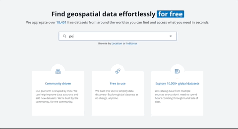
1. Finding geospatial datasets instantly for free
Finding the right geospatial dataset can be incredibly frustrating. We sift through Google Earth Engine, Humanitarian Data Exchange, etc, only to come up empty-handed and conclude the dataset we need simply doesn’t exist.
And I know this is a problem for all of us.
Every week, people reach out asking if I can help locate specific geospatial datasets for certain countries.
So I was absolutely thrilled to discover the Geospatial Data Catalog. It’s a new free tool that catalogs over 18,000 (free) geospatial datasets. It also provides info on:
Time-series
Spatial resolution
Dataset description
Key variables of the dataset
Link to the website so you can download the data
It was built by Rob Johnsen, who builds geospatial platforms for the World Bank. It’s still in beta testing, and Rob is keen for any feedback or suggestions you’ve got. You can even add new datasets if you notice something missing.
The hope is that this tool becomes driven by the community. We can submit new datasets, provide feedback on data descriptions, and most importantly help improve the discoverability of geospatial data. This will help grow the size of the geospatial pie for all of us.
Sign up here and use the discount code: GEO4LYF. (Just kidding, it’s totally free — I wouldn’t do that to you).
2. Improving the transparency of geospatial predictions using Geoconformal Prediction

In a certain niche corner of the internet (where I seem to spend time), there’s been a bit of hype around ‘conformal prediction’. In simple terms, conformal prediction provides a way to attach ‘confidence’ or ‘uncertainty’ to a machine learning model’s predictions.
So how does this work in practice?
We can work through an example to illustrate: let’s say that we’ve got an already trained model that predicts the price of houses. Conformal prediction takes a small set of data (the ‘calibration set’) and checks how far the model’s predictions deviate from the true values.
Then, when we want a new prediction (where we don’t have true values), conformal prediction uses what it learned from the past deviations to provide a range or interval around the prediction. It essentially guarantees that these intervals capture the true value a certain percentage of the time (e.g. 90% of the time).
So how is this different to standard OLS regressions that you’ve heard about?
It works on more complex models (i.e. highly non-linear models), and it doesn’t force you to make certain assumptions about the data (e.g. that errors are normally distributed, there’s no autocorrelation, homoscedasticity, etc.).
Geoconformal prediction
In any case, a new paper from some folks at MIT and the University of Munich introduces GeoConformal prediction puts forward a framework that measures the uncertainty of geospatial predictions. This addresses the ongoing issue that geospatial models often overlook reliable uncertainty estimates. This is something I’ve seen a lot of, and which undermines trust in predictions.
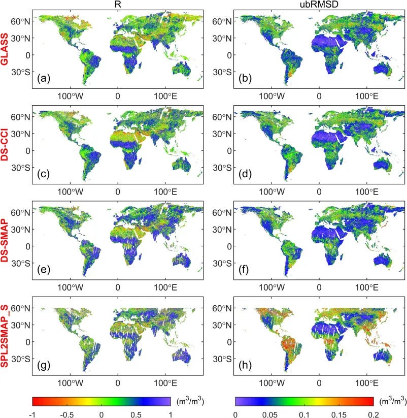
The researchers used two main case studies: spatial regression for housing prices in Seattle, and spatial interpolation of temperature data in Los Angeles. GeoCP adapts conformal prediction by adding geographic weighting, which ensures that prediction intervals vary from place to place.
The datasets included over 21,000 housing records and 90 days of temperature readings, and they tested GeoCP with models such as XGBoost, Ordinary Kriging, and deep learning approaches.
They found that GeoCP covered the true value about 93% of the time—better than the 81% coverage from bootstrapping. (Bootstrapping involves creating many versions of the dataset by randomly choosing observations — sometimes repeating some of them — and leaving others out. You then run the same model on each new version. If the model’s predictions jump around a lot from one version to another, that signals higher uncertainty. If they stay fairly steady, it indicates more confidence in the predictions.)
They also noticed that including details like local averages or precise coordinates shrank the uncertainty even further and boosted confidence in the final results.
In short, this could help improve transparency in geospatial predictions and address discrepancies between datasets that claim to measure the same thing (more on that here).
Geospatial datasets
1. Soil moisture dataset
If you’re like me and prefer your soil moist, then you’re in for a treat. The first global 1 km Sentinel-1 soil moisture dataset is now available. You can access the dataset here.
2. All-weather disaster response data

The BRIGHT dataset combines pre-disaster optical imagery and post-disaster SAR data for high-resolution analysis. It covers 12 global regions and 7 disaster types (natural and human-made) and offers precise 0.3–1m imagery with detailed building damage classifications. You can access the data and code here.
3. More NASA datasets

NASA’s January 2025 Earth Science data roundup introduces a bunch of different datasets. Also, over 120 of NASA's Earth observation products are now accessible through Esri's ArcGIS Living Atlas of the World.
Other useful bits

Microsoft's AI for Good Lab, in collaboration with Planet Labs, used deep learning models on high-resolution satellite imagery to assess fire damage in LA’s Palisades. They identified 2,355 affected buildings. Explore the analysis here.
UAE-based SpaceTech company Space42 has launched the Thuraya 4 (T4) satellite aboard SpaceX's Falcon 9, marking a milestone in geospatial data and connectivity. Thuraya 4, equipped with advanced onboard processing and a 12-metre antenna, will provide premium geospatial analytics and secure communication services once it reaches its geostationary orbit.
Moody’s has acquired geospatial intelligence provider, CAPE Analytics. Moody’s will be combining CAPE’s geospatial analytics with their intelligent risk platform and catastrophe risk modelling. It’s yet another sign that geospatial data science is pretty useful for risk assessments and insurance purposes.
Jobs
UN Department of Economic and Social Affairs (DESA) is looking for a Director to head their Statistics Division.
Resources for the Future is looking for an Intern to help analyse how sea level rise affects business decisions.
One Acre Fund is looking for a Geospatial Data Science Analyst who will support various remote sensing projects.
The World Food Program is looking for a Data and GIS analyst in Beirut, Lebanon.
First Street is looking for a Senior Geospatial Data Engineer in New York City.
Geospatial Insights of the Week
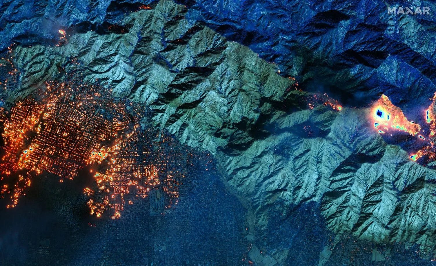
This thread captures the significant devastation from the California wildfires with various satellite imagery from Maxar, Planet, etc.
That’s it for this week.
I’m always keen to hear from you, so please let me know if you have:
new geospatial datasets
newly published papers
geospatial job opportunities
and I’ll do my best to showcase them here.
Yohan