Measuring sub-national government corruption across the world
PLUS: NASA and IBM's newest climate model, assessing the impact of climate change on food security, and new geospatial datasets
Hey guys, here’s this week’s edition of Spatial Edge — a weekly round-up of geospatial news. The goal is to make you the coolest person at your next dinner party by giving you a rundown of the geospatial data science space in less than 5 minutes.
In today’s newsletter:
Subnational Corruption: New dataset covers 1,473 global regions.
Climate Change Impact: Food security threatened by heat and water stress.
NASA-IBM Climate Model: Prithvi-WxC enhances weather forecasting.
Eurostat Population Data: 2021 geospatial dataset update.
Global Crop Data: MIRCA-OS offers comprehensive crop statistics
To kick off, podcasts.
I had the pleasure of sitting down with Lyric Hughes Hale on EconVue’s podcast, the Hale Report. We discussed use cases for geospatial data, limitations of some of the big geospatial datasets, as well as my journey into this space.
You can check it out here:
Research you should know about
1. A comprehensive dataset on sub-national government corruption
A new paper in Scientific Data provides a comprehensive dataset of sub-national government corruption across 1,473 regions in 178 countries from 1995-2022.
As someone who did their PhD on sub-national government corruption, having access to this data back then would’ve been game-changing.
The authors use data from 807 surveys, which cover over 1.3m respondents. They apply principal component analysis (PCA) to create indexes of subnational grand and petty corruption. To build the full time series, they imputed values using chained regressions.
The data can be accessed free from this link.
2. Estimating the impact of water and heat stress on food security
New research published in Scientific Reports examines the impact of climate change on food security, using geospatial data.
They use a large dimensional global climate and trade model to assess how different climate scenarios impact food supply and food security.
They find that, due to heat and water stress:
Food production will decline by 6-14% by 2050
Between 556 million - 1.36 billion additional people will face severe food security by 2050
The largest declines in food production are projected for Africa, Australia, China, India and parts of Central America
These findings show how important irrigation is for agriculture - but this essentially relies on water availability. As a result, we might expect shifts in trade flows from low to high ‘water stress’ regions (i.e. areas where demand for water exceeds supply).
3. NASA and IBM’s Weather-Climate Foundation Model
NASA and IBM have continued their collaboration to release Prithvi-weather-climate (Prithvi-WxC), a weather and climate foundation model.
I’ve previously covered NASA and IBM’s original Prithvi foundation model. However, the new Prithvi-WxC model increases the resolution of existing climate models by a factor of 12. It can create pretty accurate short to medium-range forecasts for granular locations.
Here’s a handful of use cases to give you a sense of what it can do:
Provide localised forecasts
Seasonal precipitation forecasting
Hurricane track and intensity forecasts
Severe weather and natural disaster prediction
The model was trained on MERRA-2 data from NASA. It uses a hierarchical 2D vision transformer and has 320 million parameters.
The model should be released on Hugging Face soon.
Geospatial Datasets
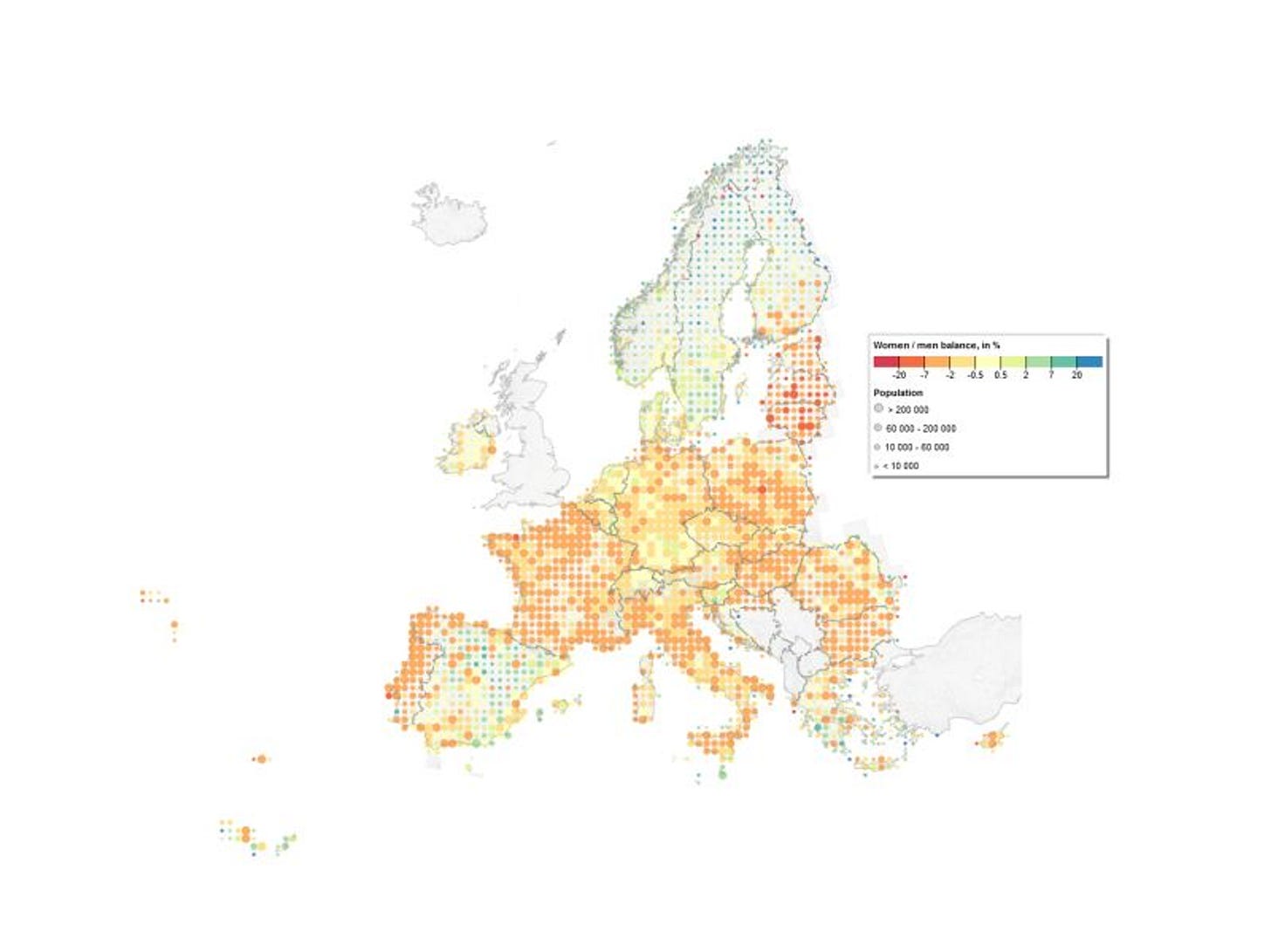
1. Geospatial population data from Eurostat
Eurostat and Geostat have released an updated geospatial dataset on population for 2021. It breaks population down by gender, age brackets, mobility, and even employment status. It provides data at 1 km2 resolution.
2. A global open-source dataset of monthly irrigated and rainfed cropped areas
A new dataset has been released which contains subnational crop-specific irrigated and rainfed harvested area statistics. The data is combined with global gridded land cover products to create a global gridded dataset, MIRCA-OS, covering the years 2000 to 2015 for 23 crop classes.
3. Comprehensive Dataset for Urban Streetlight Analysis
A dataset has been released on urban streetlights in India. Each image has been labelled and grouped into categories, which indicate whether each streetlight is functional or not. This dataset could be useful when conducting nightlights-related studies.
Other useful bits
Global Fishing Watch has released an interactive map of fishing activity at sea. They also cover dark fishing. By analysing GPS and radar data, they found that 75% of industrial fishing vessels are not publicly tracked.
SkyFi have integrated True Elements’s Flood and Water Resiliency Reports into their platform. It allows users to assess the vulnerability of infrastructure to flooding and extreme precipitation.
The new Dask-ee python package can turn a Google Earth Engine feature collection into a dask data frame with a single line of code.
The new MapGL R package makes the latest version of Mapbox GL JS and MapLibre available to R users.
Jobs
SpaceKnow is looking for a Machine Learning Engineer for Geospatial AI.
ESA is looking for an Internal Research Fellow in Planetary Robotics.
Amazon is looking for a geospatial data engineer. The position will be responsible for Amazon World-Wide Sustainability’s geospatial data, including ingestion, documentation, quality, and metadata management.
GAF Munich is looking for a Project Manager in Earth Observation and Copernicus Land Cover and Land Use (LCLU) downstream Services.
Development Seed is recruiting a Geospatial Services Engineer to develop geospatial data services and advance open-source geospatial technologies.
The University of Southampton is searching for a Research Fellow in Urban Studies and Data Science.
The United States Geological Service is looking for a fellow specialising in remote sensing of agricultural practices.
The United Nations Department of Economic and Social Affairs are looking for two geospatial information offices to be a part of the Secretariat for the Committee of Experts on Global Geospatial Information Management. You can check out the opportunities here and here.
That’s it for this week.
I’m always keen to hear from you, so please let me know if you have:
new geospatial datasets
newly published papers
geospatial job opportunities
and I’ll do my best to showcase them here.


