

🌐 Taking precision agriculture to new heights
PLUS: Cop-Gen: A generative approach to Earth observation, and more.

Hey guys, here’s this week’s edition of the Spatial Edge — we’re sort of like Playboy for geospatial nerds. In any case, the aim is to make you a better geospatial data scientist in less than five minutes a week.
In today’s newsletter:
Rice Monitoring: Drones improve crop health estimation.
Generative Earth Observation: COP-GEN captures real-world variability.
Damage Assessment: 3D disaster dataset for structural damage.
Levee Erosion: Multi-scale wave overtopping dataset.
Ocean Nutrients: Warming seas increase nutrient stress.
Research you should know about
1. Taking precision agriculture to new heights
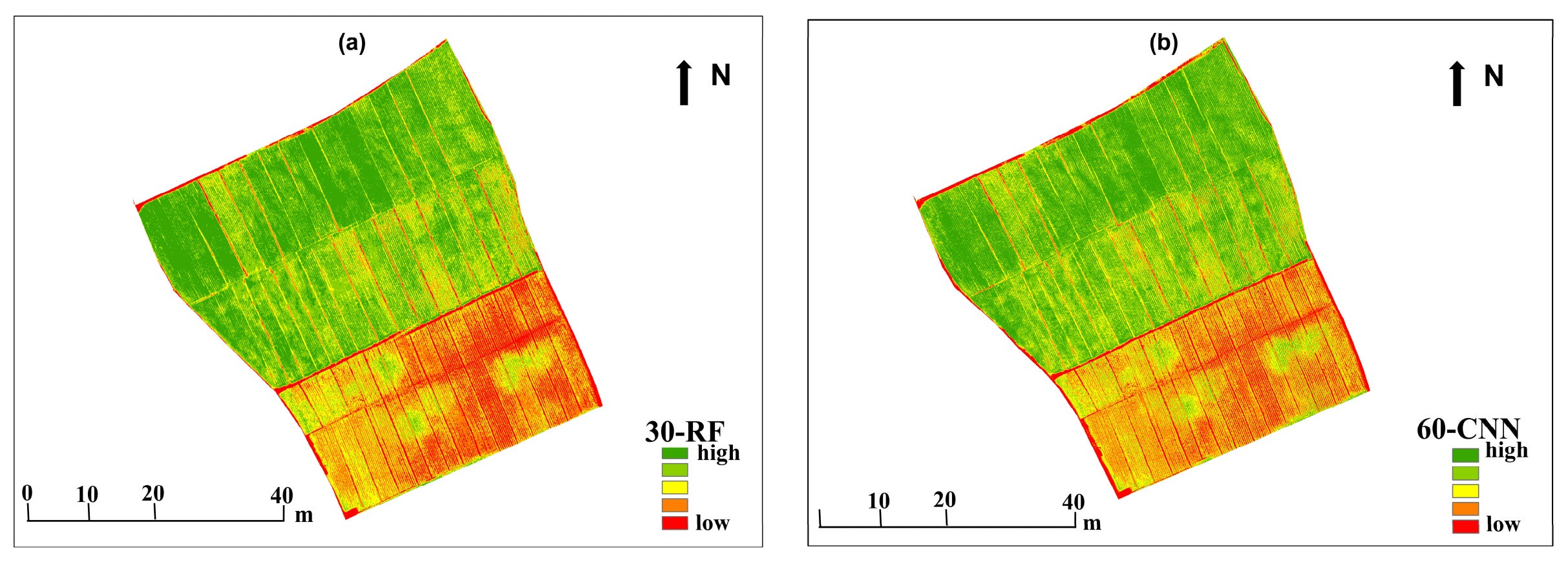
If, like me, you live in Asia, then you know that rice is kinda a big deal. Monitoring the Leaf Area Index (LAI) of rice crops is an important part of understanding their health and water use efficiency. Farmers and researchers traditionally measure this by hand, which is incredibly slow, labour-intensive, and difficult to scale across massive agricultural operations. To speed things up, scientists are increasingly turning to drones equipped with advanced cameras. However, standard drone imagery often struggles with changes in lighting or gets confused by the soil background when the crop canopy is either too thin or too dense. A new paper from Scientific Reports tries to address this by blending multiple types of drone data to create a highly accurate monitoring framework specifically tailored for rice during its critical booting stage.
The research team flew drones equipped with both standard RGB and multispectral cameras over rice fields at altitudes of 30 and 60 metres. Instead of just looking at basic colours, they extracted a complex mix of colour indices, spectral vegetation indices, and spatial texture features. They also developed new texture feature indices that specifically couple spatial patterns with spectral data. When they fed this fused data into six different machine learning models, the results were highly impressive. They found that flying at a lower 30-metre altitude and combining colour, vegetation, and the new texture indices yielded the best outcomes. Using this specific combination, a Convolutional Neural Network and a Random Forest model achieved an accuracy score of over 90%, proving that blending spatial and spectral data easily overcomes the blind spots of using just one type of sensor.
These findings provide a pretty interesting solution for those looking to implement precision agriculture. By confirming the ideal flight altitude and the exact mix of data features needed, the researchers have created a reliable blueprint for tracking crop health from the sky. Interestingly, the study also noted that standard machine learning models like Random Forest performed incredibly well given the relatively small sample size, sometimes even outpacing more complex deep learning networks.
2. Cop-Gen: A generative approach to Earth observation
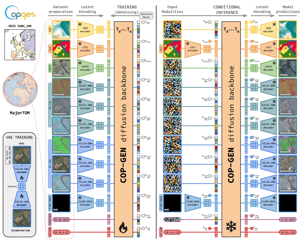
In the geospatial space (or ‘geospace’, if you will), satellites gather petabytes of data daily, capturing everything from optical imagery and radar to terrain elevation and land cover. The challenge lies in integrating these diverse “modalities” into a single, cohesive system. Traditionally, we’ve relied on deterministic models, which take a set of inputs and produce a single, averaged “best guess” output. However, the real world is obviously pretty ambiguous. A single type of terrain or land cover could look pretty different depending on the weather, the season, or the lighting. By forcing a single output, these models fail to capture the true variability of Earth’s physical systems.
Researchers built COP-GEN to address this: a new multimodal generative model designed to handle the massive influx of data from the Copernicus satellite program. COP-GEN uses a “latent diffusion transformer” architecture, which allows it to process all the different types of satellite data at their native resolutions simultaneously. Instead of producing one averaged image, COP-GEN acts as a stochastic model, meaning it generates multiple, physically plausible versions of a scene based on the input data. The model can even perform “zero-shot” translation, meaning it can fill in missing data (e.g. generating a realistic optical image using only radar and elevation data) without needing to be retrained for that specific task.
When tested against a massive global dataset, COP-GEN proved pretty good at capturing the natural variance of the Earth’s surface. In a head-to-head comparison with a leading deterministic model, COP-GEN was able to cover 90% of the possible real-world variations of a scene, whereas the competing model collapsed to just 2.8%, producing the same image over and over. You can access the code here.
Geospatial Datasets
1. Post-disaster structural damage 3D dataset
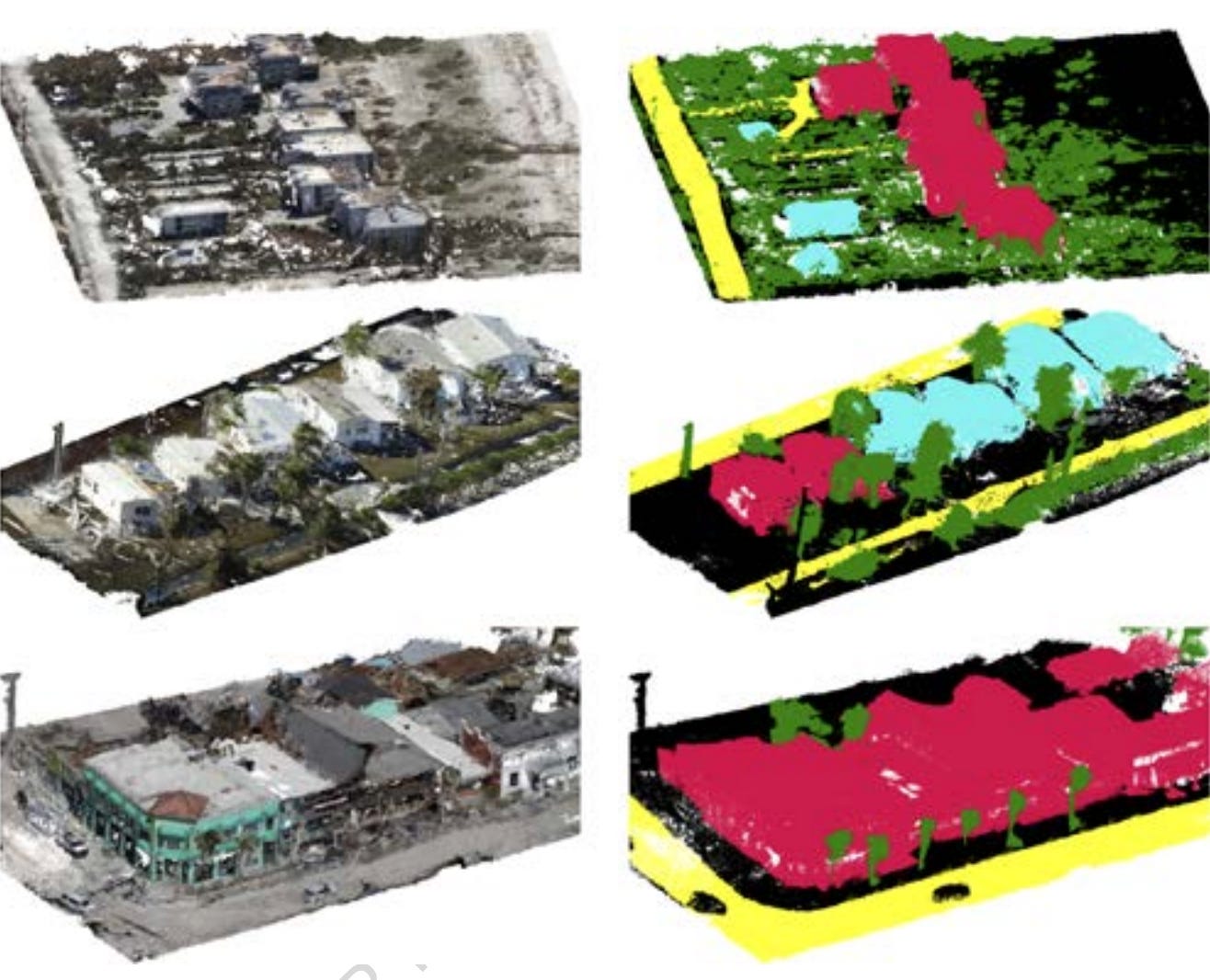
The 3DAeroRelief dataset provides the first 3D benchmark dataset specifically designed for large-scale outdoor post-disaster structural damage assessment. It comprises dense 3D point clouds reconstructed via Structure-from-Motion and Multi-View Stereo techniques using optical RGB imagery captured by low-cost unmanned aerial vehicles over hurricane-damaged areas. You can access the data here and the code here.
2. Levee erosion and wavefront velocity dataset
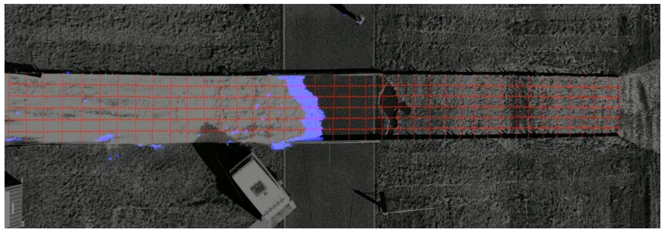
The collection provides a multi-scale dataset compiled from four experimental field campaigns and corresponding laboratory tests designed to evaluate the spatiotemporal erosion resistance of earthen levee cohesive clay covers under wave overtopping loads. You can access the data here and the code here.
3. Glacier inventory dataset

The Tajikistan Glacier Inventory (TGI) provides a national-scale glacier dataset for Tajikistan derived from 3-metre resolution PlanetScope satellite imagery acquired in 2024. The collection maps 12,325 glaciers covering a total area of 7,720.26 square kilometres. You can access the data here and the code here.
Other useful bits

A new study combining two decades of NASA Aqua satellite data with global ocean surveys has mapped nutrient stress in marine microorganisms caused by warming waters. By tracking shifts in the carbon-to-chlorophyll ratio of phytoplankton alongside genetic markers, researchers found that ocean stratification is increasingly limiting nutrient availability, particularly in subtropical gyres.
The EU is investing billions of dollars in several large-scale rail tunnels to bypass natural geographic barriers and shift passenger and freight traffic from air and road to rail. While mega-projects like the Gotthard, Brenner, and Mont Cenis base tunnels promise to significantly reduce travel times across the continent, they face substantial construction delays, ballooning costs, and a lack of completed connecting lines from neighboring countries.
A recent article addresses the challenge of building machine learning models in geospatial applications where satellite data is abundant but accurate field labels are rare and expensive. The author outlines a practical workflow for small environmental datasets, highlighting that rigorous spatial validation and transparent mapping of uncertainty are critical to avoid artificial inflation of model accuracy.
ESA has awarded a contract to Thales Alenia Space and Airbus Defence and Space to build two Copernicus Sentinel-1 Next Generation satellites to ensure long-term continuity for Europe’s radar Earth observation capabilities. The new satellites will feature advanced C-band synthetic aperture radars that extend coverage to the polar regions and offer a fourfold improvement in geometric resolution compared to the first-generation mission.
Jobs
PAHO is looking for a remote GIS and Information Products Consultant.
Vizzuality is looking for a remote Software Engineer based in either Spain, Portugal or UK.
IOM is looking for a GIS Manager based in Berlin.
GiveDirectly is looking for a Remote Sensing Analyst based in New York.
UNITAR is looking for (1) Geospatial Analysts - Satellite Imagery and GIS and (2) Geospatial Quality, Assurance, Training and Analytical Support Specialists based in Geneva.
WFP is looking for a Geospatial Data Engineer based in Rome.
Just for Fun
A time-lapse captured from a SpaceX Dragon spacecraft shows a spectacular southern aurora caused by a recent solar event, with the phenomenon dancing directly below the vehicle.
That’s it for this week.
I’m always keen to hear from you, so please let me know if you have:
new geospatial datasets
newly published papers
geospatial job opportunities
and I’ll do my best to showcase them here.
Yohan