

🌐 The hidden health costs of global trade
PLUS: The generational toll of political violence, optimising EO with embeddings, and more.

Hey guys, here’s this week’s edition of the Spatial Edge — your weekly map to the latest geospatial news. We buffer out the noise, snap to the most interesting features, and provide geospatial puns that are even worse than the GeoDA UI. In any case, the aim is to make you a better geospatial data scientist in less than five minutes a week.
In today’s newsletter:
Trade Deaths: Global trade shifts pollution deaths abroad.
Political Violence: Conflict scars the next generation.
EO Embeddings: Compact vectors streamline satellite analysis.
SAR Matching: Off-the-shelf AI aligns disaster images
Climate Pledges: ClimActor tracks subnational climate action.
Research you should know about
1. The hidden health costs of global trade

If you’ve ever been to a city, or read about cities in books, or seen a city in a movie, then you might have experienced the joys of air pollution from fine particulate matter (PM2.5). It causes around 5.1 million deaths a year. While it’s easy to blame the countries where this pollution is emitted, the reality of global economics paints a bit more of a complicated picture. When a wealthy country imports cheap, manufactured goods, it’s effectively outsourcing the dirty, dangerous industrial work required to make them. This is basically the idea of ‘imported emissions’. Until now, scientists have struggled to map exactly how this international trade shifts the health burden of air pollution from wealthy nations to poorer ones on a country-by-country basis.
A new study from Nature Communications quantifies this by combining global economic data, air pollution transport models, and epidemiological studies. The researchers discovered that roughly 40% to 48% of all economy-related PM2.5 deaths are caused by the production of goods meant for export. Most shockingly, 14% to 18% of all global air pollution deaths occur when a wealthy country (with a high GDP) imports goods from a poorer country (with a GDP at least 50% lower). This means that high-income nations like the US and the UK are effectively exporting thousands of pollution-related mortalities to countries like China, India, and Bangladesh in exchange for cheaper goods.
This massive imbalance exposes a major flaw in how governments currently calculate the ‘externality costs’ of pollution. In countries like the US, the economic cost of pollution is only calculated based on the lives of its own citizens. If a US policy causes pollution deaths in another country, those lives are valued at zero, essentially incentivising companies to offshore their most toxic practices to the poorest nations. The researchers propose a new ‘Fair Trade in Pollution’ model that forces wealthy nations to value the lives lost in producing countries as highly as their own citizens, a shift that would drastically alter the math behind international trade policies. You can access the code for this study here.
2. The generational toll of political violence

We all know that armed conflict and political violence cause massive, immediate suffering. However, much less is known about the ripple effects these events have on the daily lives of children and young adults long after the dust settles. When a community experiences political violence, the resulting trauma, economic instability, and breakdown of local services can create a culture of insecurity. In these high-stress environments, violence is often normalised as a way to resolve disputes, leading to an increase in interpersonal violence within families and romantic relationships.
To measure this phenomenon, researchers built a massive dataset combining the Violence Against Children and Youth Surveys (VACS) with the Armed Conflict Location and Event Data (ACLED) project. By cross-referencing these two databases, they were able to track the history of political violence across nine African nations and compare it directly to self-reported instances of interpersonal violence against adolescents and young adults. The results showed a stark, long-term connection. If a community experienced a significant increase in political violence over a 15-year period, the local youth were 5.5% more likely to experience emotional violence from family members and 3.0% more likely to suffer physical violence from an intimate partner. Notably, the study found no significant link between short-term political violence and increased youth violence, proving that this is a generational, slow-burning issue.
The study also highlighted how economic factors exacerbate these dangers, with young people in poorer households being 16.9% more likely to experience sexual violence following long-term political instability. These findings prove that the scars of political violence extend far beyond the battlefield, infecting the homes and relationships of the next generation. You can access the data and code here.
3. Optimising Earth observation with compact embeddings
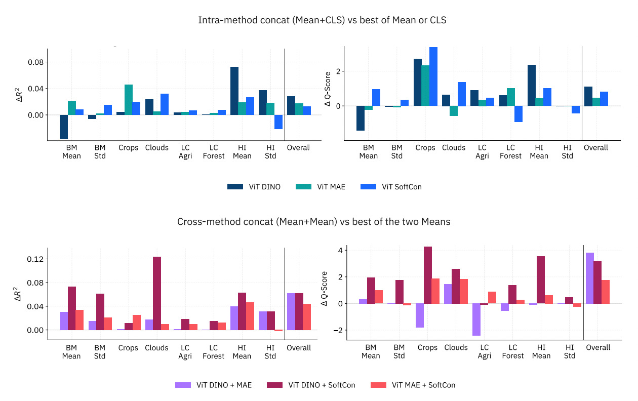
Earth observation satellites capture petabytes of multispectral imagery every day, which researchers increasingly analyse using large Geospatial Foundation Models. Instead of constantly feeding raw data through these massive models for every new task, scientists are shifting towards an embedding-centric approach. In this setup, models process the imagery once to create compact, reusable vector representations known as embeddings. However, deciding exactly how to compress this data, such as which layers of the model to use or how to pool the information, significantly impacts performance. A new study from IBM systematically evaluates these design choices to help developers build highly efficient Earth observation pipelines without sacrificing accuracy.
Using an evaluation framework called NeuCo-Bench, the researchers tested various embedding configurations across multiple tasks, including land cover classification, biomass estimation, and cloud cover prediction. They discovered that Vision Transformers consistently outperformed traditional convolutional networks like ResNet when dealing with continuous environmental variables. Furthermore, simply taking the average of the spatial features, a technique known as mean pooling, proved to be the most robust aggregation strategy across the board. The team also noted that while transformer models perform best at their final layers, convolutional networks actually produce their most useful embeddings at intermediate stages, meaning the default practice of using the final layer is often a mistake.
The findings show that carefully designed, fixed-size embeddings can compress raw satellite data by over 500 times while remaining incredibly useful for a wide range of analytical tasks. The study also highlights that different training methods excel at different tasks, meaning that combining embeddings from multiple models can further boost overall reliability. By following these design guidelines, developers can create scalable, lightweight systems for monitoring our planet.
4. Can off-the-shelf AI match optical and SAR satellite imagery?
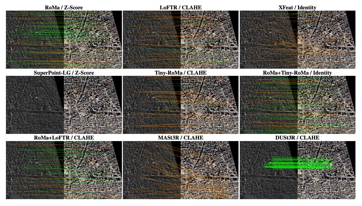
When a disaster like a hurricane strikes, thick cloud cover often makes standard optical satellite imagery useless. In these situations, responders rely on Synthetic Aperture Radar (more info on SAR here) which can see through clouds but produces grainy, distorted images that look radically different from regular photos. To quickly assess damage, analysts need to perfectly align, or “register,” these new SAR images with older optical basemaps. It’s a pretty notoriously difficult task because the two types of imagery are fundamentally different. While there are plenty of highly advanced AI image-matching tools available, almost all of them were trained on normal, ground-level photos. A new study tries to see whether these general-purpose AI matchers actually handle the extreme differences between overhead optical and SAR satellite imagery.
To find out, a new paper tested 24 different pretrained AI matchers on SpaceNet9, a dataset of paired optical and SAR satellite images. They evaluated the models in a “zero-shot” setting, meaning the AIs had to perform the task straight out of the box without any special training or fine-tuning for satellite data. The results were surprising. While models specifically trained for cross-modal tasks (like matching visible light to thermal images) performed exceptionally well, some general-purpose models performed almost identically. For example, a model called RoMa, which was only ever trained on normal photos, achieved the lowest error rate alongside the cross-modal specialist XoFTR. This suggests that the sheer size and diversity of data used to train modern foundation models gives them an unexpected ability to bridge the gap between radically different types of imagery.
However, the study also revealed that picking the “best” AI model is only half the battle. The researchers found that how the model is deployed (specifically the geometric math used to align the images and how the images are cropped into tiles) often mattered more than the choice of AI itself. E.g., simply forcing the models to use an “affine” geometry model (which assumes the ground is relatively flat) rather than a “homography” model (which accounts for complex 3D perspective) slashed the error rate by quite a lot. The key takeaway for disaster responders is that while off-the-shelf AI matchers are surprisingly capable of handling satellite data, they require careful, domain-specific configuration to be truly reliable in the field.
Geospatial Datasets
1. Global agricultural field boundary map
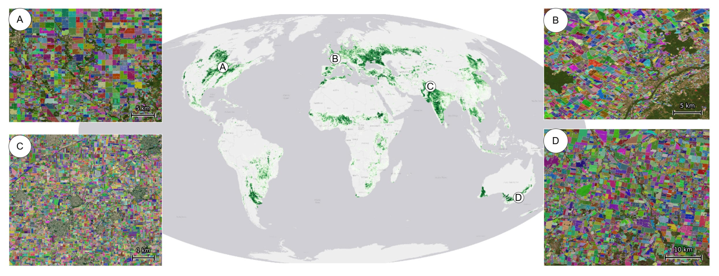
The PRUE global dataset delivers the very first wall-to-wall map of agricultural field boundaries at a pretty granular 10-m resolution for 2024 and 2025. You can access the data here and code here.
2. Spatiotemporal hyperspectral EO dataset
The ChronoEarth-492K dataset introduces the first large-scale, temporally calibrated hyperspectral self-supervised learning collection, built on NASA’s EO-1 Hyperion mission archive spanning from 2001 to 2017. You can access the data and code here.
3. Climate pledges and emissions dataset
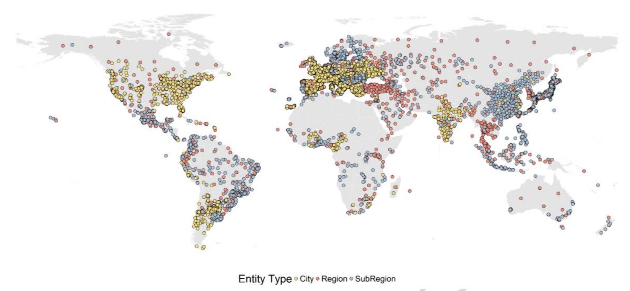
The ClimActor 2.0 database provides an expanded, openly available geospatial resource that maps climate targets, action plans, and emission inventories from subnational governments worldwide. You can access the data here and the code here.
4. National-scale sandy beach dataset
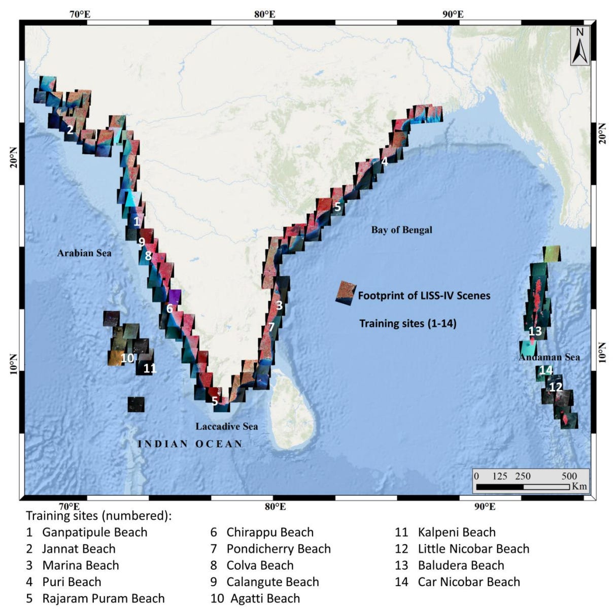
This new dataset introduces the first comprehensive, high-resolution national map of sandy beaches along the extensive 11,098.81 km coastline of India.
Other useful bits
The creators of the Global Automation Atlas have mapped how automation will unfold across 124 countries by comparing over 18,000 distinct tasks. This new tool provides an incredible 2.3 million task-country comparisons.
The new GeoX framework is impacting geospatial reasoning by using a self-play mechanism that allows AI to teach itself complex spatial logic without the need for costly human data. By generating and solving its own programming problems, this system creates a virtuous cycle of autonomous improvement that pushes vision-language models to state-of-the-art performance.
NASA and IBM’s open-source Prithvi model has become the very first AI geospatial foundation model to be successfully deployed in orbit. By running directly on the International Space Station and the Kanyini satellite, the model system can quickly analyse floods and wildfires from space, cleverly saving massive amounts of bandwidth by processing Earth observation data before it even hits the ground.
In the wake of Hurricane Melissa, Jamaica's National Spatial Data Management Branch demonstrated the power of resilient geospatial infrastructure by mapping nearly 200,000 damaged buildings within days. The nation used its National Geospatial Repository and partnered with international tech organisations to create a shared real-time dashboard, allowing emergency teams to coordinate relief and restore essential services with incredible precision.
Jobs
UNITAR is looking for (1) Geospatial Analysts - Satellite Imagery and GIS and (2) Geospatial Quality, Assurance, Training and Analytical Support Specialists based in Geneva.
WWF is looking for a Senior Conservation Data Analyst/Engineer based in Washington, DC.
Google is looking for a Technical Program Manager under their Geo team based in Singapore.
UNODC is looking for a Geospatial Information Management Intern based in Vienna.
Just for Fun
The Sentinel-6 Michael Freilich satellite has detected a massive swell of warm water moving across the Pacific Ocean, which means that El Niño will likely arrive later this year.
That’s it for this week.
I’m always keen to hear from you, so please let me know if you have:
new geospatial datasets
newly published papers
geospatial job opportunities
and I’ll do my best to showcase them here.
Yohan