Using geospatial data to estimate land value...in the metaverse
PLUS: surprising spatial relationship between nutrition and poverty, the impact of green spaces on mental health, informal transport efficiencies, and more.
Hey guys, welcome to this week’s edition of the Spatial Edge — a weekly round-up of geospatial news that you can digest in less than 5 minutes. My aim is to provide a bit of geospatial spice to your life…
In today’s newsletter:
Metaverse Land Prices: Geospatial techniques reveal location's impact.
Nutrition and Poverty: Malnutrition isn’t confined to lowest income households.
Urban Green Spaces: Trees improve mental health outcomes.
Informal Transport Networks: Efficient self-organization without planning.
Luxury Car Dealerships: ML optimizes location selection.
To kick off, podcasts.
I recently chatted with James McCammon on his AI ‘N Stuff podcast. We discussed some of the limitations of using satellite data in economics, how super-resolution can help with data accessibility and 3D geospatial models.
You can check it out here:
Research you should know about
1. Using geospatial techniques to assess land prices in the metaverse
A new study published in the Journal of Economic Geography explores how location impacts land valuation in the metaverse. I couldn’t help myself with this one — I’m a sucker for novel use cases for geospatial techniques.
Here, the researchers investigate whether traditional urban economics theories apply to land prices in the metaverse, where users can defy the laws of physics (e.g. by teleporting).
Analysing data from over 34,000 land sales in Decentraland—a blockchain-based virtual world—they examined how distances to popular locations like the central plaza, districts, and roads affect land prices. Using hedonic regression models, which assess how different factors contribute to price, they looked at whether being closer to key areas increases a parcel's value, even when users can teleport.
They found that location significantly influences virtual land prices. Parcels closer to the central plaza and main roads sold for higher prices, indicating that proximity to high-traffic areas boosts value due to increased visitor spillover—people are more likely to visit nearby parcels after visiting popular spots.
The researchers also estimated a "teleportation threshold" (what’s not to love about this). This is the distance at which users prefer to teleport rather than walk, and was around 114 to 275 metres in Decentraland. This demonstrates that even in virtual worlds, spatial relationships affect economic behaviour.
2. The (surprising) spatial relationship between nutrition and poverty
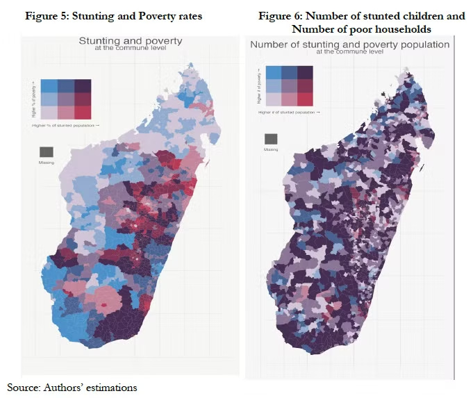
A study from the World Bank examines the spatial relationship between nutrition and poverty in Madagascar, finding that malnutrition isn't confined to the poorest households. The researchers discovered that a significant number of malnourished children come from families that aren't considered poor (in monetary terms), which is a bit of a surprising result.
Using small area estimation techniques, the team combined data from Madagascar's 2018 census, the 2021/2022 household survey, and the 2021 Demographic and Health Survey. The household survey provided detailed food consumption data, while the DHS offered measurements of children's growth, such as height and weight. By integrating these datasets, they created detailed maps showing poverty and stunting rates at the commune level. This approach allowed them to identify areas where malnutrition exists despite lower poverty levels.
The main takeaway here is that 17.9% of stunted children live in non-poor households, and 21.3% of non-stunted children are in poor households. The researchers also developed a mapping tool that categorizes communes based on both poverty and stunting rates, which helps policymakers better target nutrition interventions.
3. How green spaces impact mental health
A new study published in Scientific Reports uses Earth observation data to explore how urban green spaces affect mental health in Porto Alegre, Brazil. The research addresses the lack of quantitative data on environmental factors influencing mental well-being in low- to middle-income urban areas.
Researchers analysed land cover data from the European Space Agency's WorldCover product at 10 m resolution, focusing on tree cover across neighbourhoods. They combined this with mental health records of 5,769 diagnosed cases from the Brazilian Unified Health System's Department of Informatics (DATASUS) between 2018 and 2023. Using a couple of models (Random Forests and polynomial regressions), they examined the relationship between tree cover, the Human Development Index (HDI), and mental health indices in the city.
The study found that neighbourhoods with more than 50% tree cover had better mental health outcomes. Areas with higher HDI showed similar patterns. They explained that green spaces help mental health in a few ways:
they help people recover from mental fatigue caused by city life,
encourage community and social interactions,
restore cognitive abilities affected by stress,
reduce environmental stress like noise.
4. How efficient are informal public transport networks?
A new study published in Nature Communications examines how informal public transport networks in the Global South efficiently self-organise without central planning. The study analyses over 7,000 bus routes in 36 cities across 22 countries.
Using GPS route data sourced from OpenStreetMap, the researchers compared informal bus services with formal, centrally planned networks in the Global North. They introduced metrics like the "detour factor" to measure how much a bus route deviates from the shortest possible path between two points. This factor quantifies the extra distance travelled compared to the direct route, which essentially indicates a route’s efficiency. They also defined "detour heterogeneity" to assess how these deviations vary along different segments of a route. By dividing each route into segments (typically into thirds) they quantified detours at the beginning, middle, and end. This method allowed them to compare the ‘structural efficiency’ of routes in informal networks, which often lack fixed schedules and stops, with those in formal, centrally planned systems.
As someone who has spent a lot of time in places like Manila, where there are a lot of informal bus networks (i.e. the infamous ‘jeepneys’), I find that these results do seem to resonate. But I’m also in favour of better formal transport options — we just need to make the more efficient.
Perhaps with better sources of real-time data, and with more accurate transport models, this is becoming increasingly possible.
5. Optimising the placement of luxury vehicle dealerships
Researchers from NOVA University in Portugal, have written a new paper that applies graph neural networks to optimise luxury car dealership locations in the U.S. As someone who drives a beaten-up Skoda, I’ve never really spent much time thinking about luxury vehicle dealerships. But if this is a problem that keeps you up at night, you’ll be happy to know these researchers aim to identify the best sites for new luxury car dealerships by analysing a bunch of factors that influence location decisions.
They compiled a dataset of 65 county-level variables, including demographics, wealth indicators, transportation behaviour, luxury consumption habits, and competitor presence. Measures of regional connectedness were added using Facebook's Social Connectedness Index and commuting flows between counties. Ten different graph neural network models were trained and tested on 34 variable combinations.
An ablation study revealed that competitor presence was the most significant predictor, achieving a median F-1/3 score of 0.88 across all models. The best-performing model—a Message Passing Neural Network—combined competition data with demographics and wealth indicators, reaching an F-1/3 score of 0.92, precision of 0.94, recall of 0.74, and accuracy of 97%.
The study found that mobility data, particularly commuting flows, improved the model's performance more than social connectedness data. The model identified seven counties as promising sites for new dealerships. I guess this approach demonstrates how ML and geospatial data can help with luxury product supply distribution.
But the results are hardly surprising. You should put a luxury car dealership in areas where there are other luxury car dealerships (probably because those are located in wealthier areas).
Geospatial datasets
1. Major-TOM Digital Elevation Model
The Major-TOM team have done it again. Major-TOM Core-DEM is a massive, ML-ready global elevation dataset. It provides 30-meter resolution elevation data for nearly every land sample collected by Sentinel-1 and Sentinel-2 satellites.
2. Historical wind data
Big Earth Data has published a historical reconstruction of downscaled hourly wind data for Japan from 1958-2012. It’s available at a 5km resolution, and available in netCDF format. You can download the data here on Zenodo.
3. Outdoor trail dataset
A new study manages to extract GPS data from the massive Common Crawl (CC) corpus. CC is the largest publicly available collection of web data, which includes over 9.5 PB of data, collected since 2008.
The paper introduces a new way of extracting annotated user-generated tracks from GPX files (a common format for storing GPS data) found in CC. The resulting dataset includes 1,416 pairs of human-written descriptions and matching GPS tracks.
You can explore more of the dataset and find the reproducible code on GitHub.
4. SWOT Hydrology Data Products
NASA’s Surface Water and Ocean Topography (SWOT) Mission, which was launched in December 2022, provides a bunch of hydrology datasets:
Pixel Cloud (L2_HR_PIXC): A netCDF file with high-resolution data points showing surface water features.
River Single Pass Vector (L2_HR_RiverSP): Shapefiles with vector data on rivers, including water surface height, slope, and flow rate.
Lake Single Pass Vector (L2_HR_LakeSP): Vector data on lakes, providing information on water height and changes in storage.
Raster (L2_HR_Raster): A netCDF file with raster data of water surface elevations and other hydrological features.
You can check out more SWOT data here.
Other useful bits
The Sentinel-2C satellite successfully launched in early September, adding to the Copernicus program's Earth observation fleet. It will provide high-resolution images for monitoring agriculture, forests, and natural disasters like floods and wildfires. This launch also marked the final flight of the Vega rocket, soon to be replaced by Vega-C.
The Global Geospatial Analytics Market is expected to grow from USD 60.73 billion in 2024 to USD 87.70 billion by 2032, with a steady annual growth rate of 4.7%. Thanks to a bunch of innovations (5G and yes, AI) industries like agriculture, defence, and smart cities are using geospatial data more than ever.
Organic Maps by FOSS is a privacy-focused, open-source alternative to Google Maps, designed for Android and iOS. Built on OpenStreetMap data and a fork of the now-defunct Maps.me, it offers offline navigation without tracking your data.
NASA's Lunar Trailblazer mission, a compact satellite designed to map water on the Moon, has reached a major milestone. The spacecraft is equipped with two advanced instruments: the High-resolution Volatiles and Minerals Moon Mapper (HVM3) and the Lunar Thermal Mapper, which will help detect and analyze lunar water in various forms.
Jobs
The Swiss Federal Institute of Technology in Lausanne has a PhD position open for Nightlights image analysis for humanitarian applications.
The University of Glasgow has six positions open in their Geospatial Data Science Team: AI Research Scientist, Research Software Engineer (Geo-AI), Research Associate (Urban Analytics), Research Associate (Missing Data), Research Associate (Agent-based Modeling).
Amazon Web Services is looking for a Solutions Architect who will be within the AWS Aerospace and Satellite Services organisation.
The United Nations Environment Program is looking for a data scientist based in Nairobi.
Chapman Tate is looking for 2 GIS Specialists who will be based in Dublin.
Arup is seeking Geospatial graduates for its Geospatial Graduate Development Programme in Dublin, commencing September 2025.
KBR is looking for a Chief Geospatial Data Scientist under its Science and Space (S&S) business unit to lead its data strategy efforts.
The University of Maryland is looking for an Associate Professor in Remote Sensing under the Department of Geographical Sciences.
The European Centre for Medium-Range Weather Forecasts (ECMWF) has four positions open for Machine Learning Scientist, Data Specialist and High-performance Computing Engineer.
Just for fun

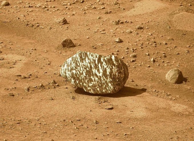
Image of Mars taken by Perseverance. Source: NASA That’s it for this week.
I’m always keen to hear from you, so please let me know if you have:new geospatial datasets
newly published papers
geospatial job opportunities
and I’ll do my best to showcase them here.
Yohan


