

🌐 We have a new health worry — Ozone
PLUS: How Meta is improving vision transformers, handling uncertainty in mapping, and more.


Hey guys, here’s this week’s edition of the Spatial Edge — a weekly round-up of geospatial news that you can digest quicker than you can say ‘dihedral corner reflector scattering’. The aim is to make you a better geospatial data scientist in less than 5 minutes a week.
In today’s newsletter:
Ozone crisis: New study warns of bigger health threats
Vision transformers: Meta addresses unintended image artefacts
StaR Maps: Handling uncertainty in geospatial features
New datasets: Explore NDVI, labour, and Earth system data
More updates: Partnerships, ecosystem mapping, and open-source tools
Research you should know about
1. It turns out we should be pretty worried about Ozone levels
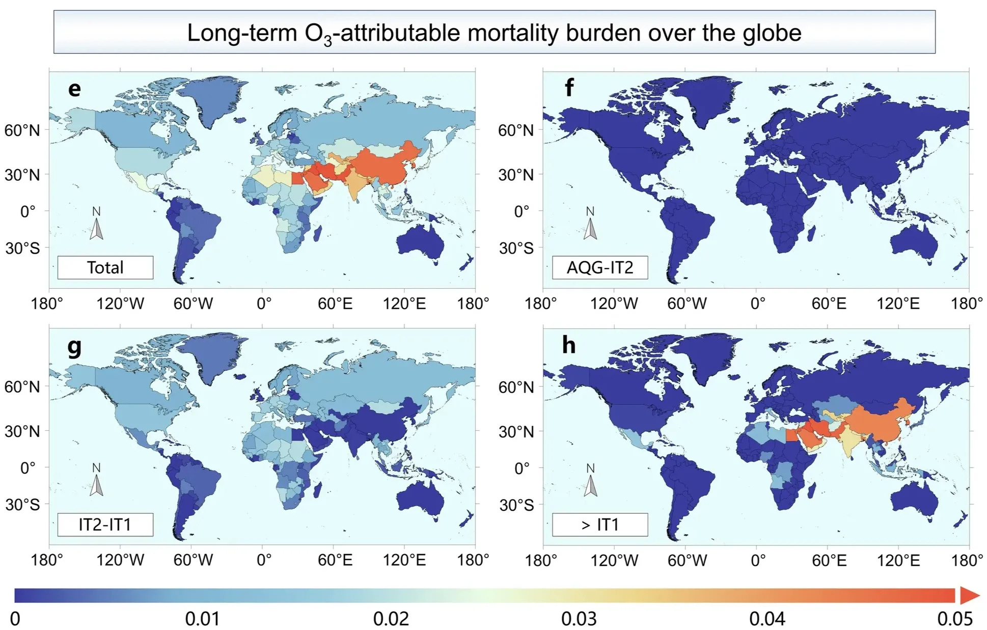
Just as we found out that last year was the hottest year on record, a new study published in Nature Communications has found that ozone pollution is now more ubiquitous than a Starbucks cafe. In short, the paper argues that the impact of ozone air pollution on health has been massively under-reported.
The researchers introduce a geo-ensemble learning model to estimate daily ozone levels at a 5km resolution, with a particular focus on short-term and long-term population exposure and mortality risks.
They combine high-resolution satellite data from TROPOMI (for nitrogen dioxide and formaldehyde), meteorological and chemical information from ERA5 and CAMS, and over 7000 in-situ monitoring stations worldwide.
The findings?
66.2% of the global population experiences short-term ozone pollution for more than 30 days each year
94.2% face continuous long-term ozone exposure
0.177 million annual deaths from short-term exposure
1.407 million annual deaths from long-term exposure 🤯
The bottom line is that ozone-linked deaths are higher than what was found in earlier studies, which had been mainly limited to examining respiratory conditions. This is particularly the case in mid-latitude Asia and parts of the western United States, where the greatest mortality burden was observed.
I guess this means it’s just a matter of time till your favourite bio-hacker releases an at-home ozone testing kit.
You can access the code here.
2. How Meta is addressing artefacts in vision transformers

As we’ve discussed in last week’s edition of the Spatial Edge, vision transformers (ViTs) in geospatial data science are all the rage. However, they’re by no means a perfect tool.
A new study from Meta examines how large Vision Transformers can create unintended artefacts. Transformers break up images into smaller chunks (i.e. patches) for processing. These artefacts occur mostly in uniform or repetitive image areas (like large stretches of sky or grass), which don’t carry a lot of unique features.
Instead of preserving local details for those patches, the model mistakenly uses them to store “global” information about the entire image. This reduces their usefulness for tasks that require a lot of granularity, like segmentation.
In ViTs, each image patch is converted into an “internal representation” — i.e. a vector that encodes how the model interprets that patch. The study shows some patches end up with unusually high values in their representations.
As a solution, the authors insert “register tokens.” These extra tokens are placeholders that aren’t linked to any specific patch of the image. During training, the model figures out it can store the overall scene information (“global” context) in these placeholders.
Because the placeholders take on the job of keeping track of the big picture, the original patches can keep focusing on their local details, rather than mixing in global information. In the end, when the model makes its predictions, it has clear patch-level details plus a centralised spot for the image-wide summary. This leads to smoother and better results for downstream tasks like segmentation.
You can access the code and documentation here.\
3. Handling uncertainty in geospatial datasets with StaR Maps

A new study from a team at the Honda Research Institute Europe introduces StaR Maps, a new way to handle uncertainty in geospatial data — particularly in relation to navigation.
Traditional digital maps rarely show how uncertain certain features might be. For example, the precise location of a road or building might actually be a bit off. StaR Maps tries to address this by providing confidence estimates for each feature.
The authors begin with crowd-sourced data, such as OpenStreetMap, and add ‘uncertainty parameters’ to each road, building, or other feature. They then draw random samples to see how maps might look under different assumptions. Distance queries (like checking how far away a drone is from the nearest road) become probability distributions, reflecting the range of possible scenarios.
This approach supports tasks like route planning or verifying safety constraints because it gives you the likelihood that a path avoids certain areas or stays within certain bounds.
Early results show that StaR Maps can give planners, autonomous vehicles, and other systems a clearer sense of where map data might be off, leading to better decisions.
Geospatial datasets
1. Earth system spatio-temporal data

The DeepExtremeCubes database compiles over 40,000 minicubes spanning 2.5 × 2.5 km each. It captures Sentinel-2 satellite imagery, ERA5-Land climate data, and land cover/topographical maps from 2016 to 2022. You can access the code here.
2. Local labour markets database

The Database for Local Labour Markets Analysis in Mexico, provided by Banco de México, provides data on subnational employment trends, wages, and demographic factors.
3. Reconstructed vegetation index dataset

A new study in Scientific Data introduces a 30 m 8-day NDVI dataset for China (2001–2020) that has been developed using the InENVI machine learning framework, merging MODIS and Landsat imagery. You can access the code here.
Other useful bits

SkyFi is making Earth observation data easier to access, and now they’ve partnered with Planet to further streamline data availability. This is a pretty cool colab that aims to democratise satellite imagery, providing faster, and easier access.
GeoJupyter is reimagining geospatial computing by combining the ease of desktop GIS tools, the flexibility of coding, and the collaboration of Jupyter notebooks. Right now, things are still in development, but there’s a community chat space on Zulip and a community calendar if you want to get involved.
A pretty ambitious project is underway to create a comprehensive global ecosystem atlas, mapping every ecosystem on Earth. Over half of the world’s ecosystems are unmapped, hence the project is aiming to create the first global map by 2026.
Random fact of the day: did you know desert dust helps feed the ocean? When winds carry dust over the sea, it delivers nutrients that fuel massive phytoplankton blooms, which support marine life and even impact the global carbon cycle.
Jobs
EURAXESS is looking for a post-doc in deep learning for poverty and malnutrition prediction.
The World Meteorological Organization (WMO) is looking for a Country Engagement Specialist Consultant to work with the Group on Earth Observations (GEO).
UNDP is looking for a home-based Data Science Fellow to work on how to deploy frontier technologies such as AI, ML, LLMs, etc.
The NASA Develop Program is now accepting applications. This is perfect for those interested in remote sensing and GIS, especially in the field of Earth Science.
Fact of the week
NASA’s latest data shows the Northern Hemisphere is heating up faster, with the Arctic warming the most—a trend called Arctic amplification. This happens because land warms quicker than oceans, and ice loss speeds things up even more.
That’s it for this week.
I’m always keen to hear from you, so please let me know if you have:
new geospatial datasets
newly published papers
geospatial job opportunities
and I’ll do my best to showcase them here.
Yohan
Amazing compilation. Thanks a lot!