

🌐 How Google is extending vegetation maps beyond national borders
PLUS: the hidden heat threat to coastal ecosystems, and predicting water quality with AI

Hey guys, here’s this week’s edition of the Spatial Edge — your weekly geospatial roundup that drops almost as frequently as France changes Prime Ministers... In any case, the aim is to make you a better geospatial data scientist in less than five minutes a week.
In today’s newsletter:
Wildfire Mapping: Google uses embeddings to predict vegetation types.
Mangrove Heat: Rising seas threaten coastal ecosystem recovery.
Water Quality: AI ensemble predicts rivers with near-perfect accuracy.
Radiation Data: Longwave record captures 41 years of variability.
Habitat Maps: Global projections for endangered vertebrate species.
Research you should know about
1. How Google is using geospatial embeddings to map wildfire risk
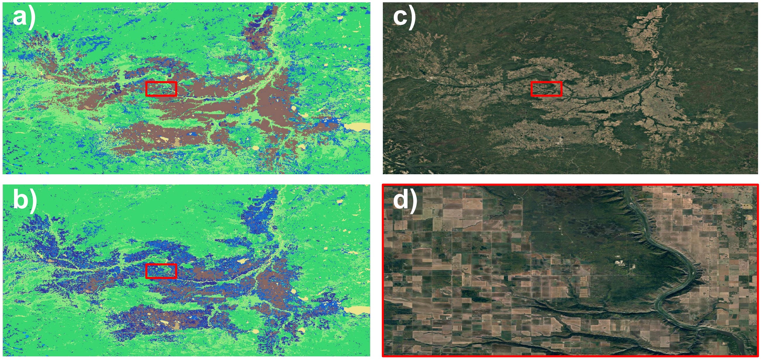
I’ve previously discussed Google DeepMind’s AlphaEarth Foundations Model in this blog. The bottom line is that it provides 64-dimensional, global embeddings at 10 m resolution, learned from Landsat and Sentinel data. You can think of these as a beefed-up version of principal component analysis. The complexity of all of these satellite images has been distilled into just 64 features that you can use in a model.
Anyway, a new paper from Google’s X (the Moonshot Factory) - not to be confused with Elon’s X… shows how these embeddings can be used as inputs for machine learning models to predict environmental features in places where labelled data is missing.
The researchers tested this by taking the US LANDFIRE vegetation dataset, which maps vegetation types for wildfire management, and extending it into Canada. They trained several models, including logistic regression, random forests, gradient boosted trees, and a deep learning segmentation model, all using AEF embeddings as inputs. Once trained on US data, the models were able to infer vegetation types in Canadian regions with no existing labels.
Performance varied depending on the task. Simpler classifications with fewer vegetation types achieved accuracies of around 70 percent, while more detailed classifications with 80 classes saw accuracy drop closer to 40–50 percent. Among the models, random forests generally delivered the strongest results, although they showed signs of overfitting, while the segmentation model produced smoother and more consistent vegetation maps. In any case, it’s just a neat example of how to use these embeddings for building out environmental datasets pretty easily.
In a world without embeddings, you’d need to do a lot more data wrangling and likely build more complex deep learning models to get similar results.
2. The hidden heat threat to coastal ecosystems
Schmucks like me don’t really appreciate mangroves. In reality, mangroves are pretty important coastal ecosystems that protect shorelines, store carbon, and provide food and materials. Over the past few decades, global mangrove loss slowed and even stabilised in some regions, leading to optimism about ambitious restoration targets such as those set by the Global Mangrove Alliance. However, new research shows that rising sea surface temperatures may undermine these efforts, cancelling out potential gains from conservation and socioeconomic development.
The study used global panel data covering climate, GDP, and mangrove area at 1° resolution. It found that higher incomes can eventually encourage mangrove recovery, often through reduced extractive use and stronger regulation. Warmer seas, on the other hand, have a non-linear effect. Initially, fewer cold days can allow mangroves to expand, but beyond a heat threshold, damage sets in. This effect means that by 2100, under a high-growth, high-warming scenario, mangrove area could be 150,000 hectares smaller than if climate change were not a factor.
The economic impact is substantial. By the end of the century, the annual value of lost mangrove services could reach 28 billion USD, most of it in Asia, followed by Africa, Latin America, and only a small share in OECD countries. These services include storm protection, water regulation, carbon storage, and cultural values. The study highlights that while prosperity alone might have driven global mangrove recovery, warming oceans will stall this progress, shifting the balance of ecosystem service gains and losses unequally across regions.
You can access the data here.
3. Predicting water quality with AI

A new study in Scientific Reports shows how machine learning can be used to predict water quality with near-perfect accuracy. Researchers trained a stacked ensemble model on almost 2,000 river water samples from India, combining six algorithms (like XGBoost and CatBoost) with a linear regression meta-learner. The result was a model that hit an R² of 0.995 and kept error rates very low, outperforming all individual models by a fair margin.
The team also tackled a pretty big barrier in environmental AI: interpretability. By integrating SHAP (Shapley Additive explanations), they could show which water quality parameters mattered most for predictions. Dissolved oxygen, biochemical oxygen demand, conductivity, and pH turned out to be the main drivers, aligning with what regulators and ecologists already use in practice.
What’s great is that the framework is ready for real-time deployment. With IoT sensors feeding in data on a continuous basis, the system could support live monitoring and automated alerts for water managers. That means early warnings for pollution events, stronger regulatory oversight, and more confidence in protecting water supplies.
You can access the data here.
Geospatial Datasets
1. Longwave radiation components dataset

LessRad provides a 41-year global record of hourly (5 km) surface longwave radiation components (LWDR, LWUR, and LWNR) derived from MODIS, ERA5 and GLASS, and validated against 565 ground stations. It captures fine-scale variability across land and ocean. You can access the three sub-datasets here: LWDR, LWUR, and LWNR. You can also find the code here.
2. Global habitat distribution dataset

This global habitat distribution for endangered vertebrates (2020–2100) maps habitat suitability for 2,571 amphibians, 617 birds, 1,280 mammals, and 1,456 reptiles at 1 km. You can access the data here and the code here.
3. Terrestrial ecosystems NPP dataset

Global NPP database (1959–2023) compiles above- and belowground net primary production records from 456 terrestrial sites across forests, grasslands, croplands, peatlands, tundra, and shrublands. You can access the data and code here.
4. Outdoor ultra-wideband dataset

This comprehensive outdoor UWB dataset captures static and dynamic measurements under line-of-sight (LOS) and non-line-of-sight (NLOS) conditions, designed to study multipath effects in real-world outdoor environments. It includes UWB ranging, received signal strength (RSS), channel impulse response, plus synchronised IMU and RTK-GNSS data, enabling analysis of signal propagation, localisation errors, and anchor placement strategies. You can access the data here and the code here.
Other useful bits

ESA has picked WIVERN as its 11th Earth Explorer mission. It’s set to measure winds inside clouds (yes this is a thing) with a cutting-edge Doppler radar. The satellite will improve hazardous weather forecasts, profile rain and snow, and add important data to climate records.
International Crisis Group has launched eEARTH, a tool that blends data analytics with regional expertise to anticipate resource-related conflict. Built from work on climate-security risks in the Horn of Africa, it tracks early signs of instability before they escalate.
A new visualisation from CliMoHub highlights the top journals publishing on environment-related migration. It shows where the most influential and prolific research on climate, environment, and human mobility is being published.
Bangladesh’s first satellite once symbolised national pride, but things have shifted as its engineers face long shifts, underused capacity, and an uncertain future as Starlink expands in the country. With the Bangabandhu Satellite-1 set to shut down by 2033, the team fears their hard-earned expertise may soon be left idle.
Jobs
First Street is looking for a Senior Data Scientist based in New York under its Science and Economics Department.
FAO is looking for an Information Technology Developer in various locations.
ICRC is looking for a GIS Associate based in Geneva to support its Analysis and Evidence Unit.
CERN is looking for a Geomatics Engineer based in Geneva.
The UN Office for Outer Space Affairs is looking for an Intern for Earth Observation for Water Management based in multiple duty stations— Bonn, Vienna, and Beijing.
Just for Fun

Hideo Kojima is teaming up with Niantic Spatial to create an augmented reality project that blends his signature storytelling with real-world environments. The collaboration involves using Niantic’s geospatial AI to turn the world into an interactive canvas. Zuckerberg will be jealous…
That’s it for this week.
I’m always keen to hear from you, so please let me know if you have:
new geospatial datasets
newly published papers
geospatial job opportunities
and I’ll do my best to showcase them here.
Yohan