


Hey guys, here’s this week’s edition of the Spatial Edge. If you’ve ever considered calling your next kid, ‘WGS84’, we have one thing to say to you: welcome home… In any case, the aim is to make you a better geospatial data scientist in less than five minutes a week.
In today’s newsletter:
Self-Play AI: Self-training model masters geospatial reasoning without labels.
Crop Mapping: AlphaEarth embeddings replace manual feature engineering.
Street Generation: Diffusion models create controllable urban street designs.
Robustness Benchmark: EarthShift tests real-world satellite model generalisation.
Earth Dataset: WorldTensor unifies global environmental and socioeconomic data.
Climate Data: Bias-corrected global climate projections through 2050.
Research you should know about
1. Self-playing AI masters geospatial reasoning without human labels
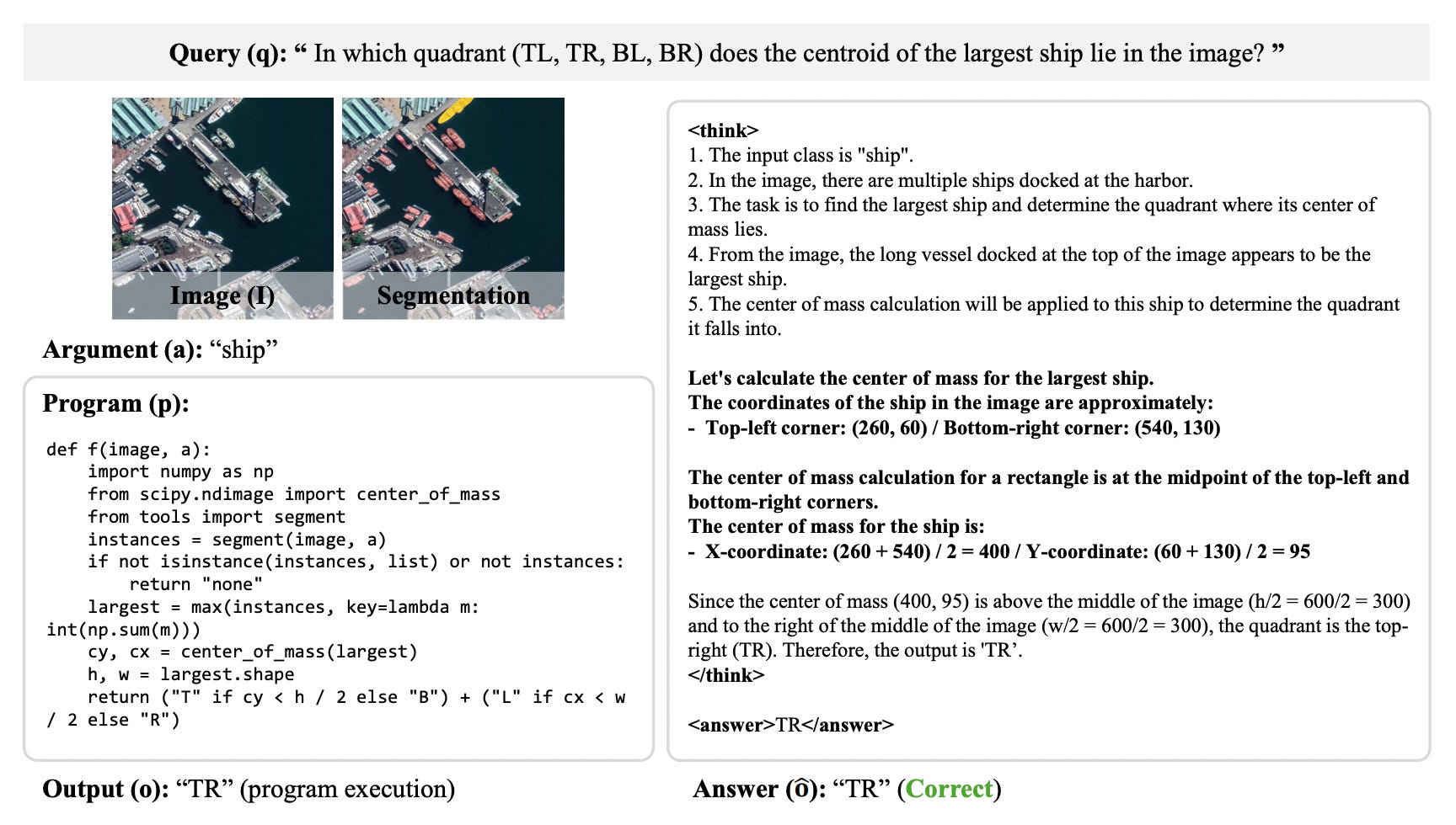
Training vision-language models to understand satellite and aerial imagery usually requires massive, human-curated datasets. But complex geospatial reasoning (such as analysing object adjacency, counting instances, or comparing areas) creates a combinatorial explosion of possible questions that manual annotation simply can’t cover. To bypass this problem, a new paper introduces GeoX, an autonomous self-play framework that masters spatial reasoning without using any human-annotated question-answer pairs. Instead of relying on static labels, GeoX alternates a single model between two roles: a proposer that programmatically constructs geospatial problems over unlabeled remote sensing images, and a solver that attempts to answer them.
The framework structures these problems as executable Python programs using an underlying library of geometric, topological, and aggregation primitives, alongside an open-vocabulary segmentation tool. To build robust structural comprehension rather than simple pattern recognition, the system forces the model to interrogate each proposal under three distinct reasoning modes: abduction (inferring the input arguments from observed outputs), deduction (predicting outputs from given parameters), and induction (synthesising the underlying program code from input-output examples). A programmatic verifier then executes the code to supply an objective reinforcement learning reward, which incentivises the proposer to create learnable, frontier-pushing challenges and the solver to derive correct answers.
When evaluated zero-shot across multiple remote sensing visual question answering and object counting benchmarks (including RSVQA-HR, EarthVQA, and GEOBench-VLM), GeoX consistently outperformed its base foundation models by an average of up to 5.5 points. Interestingly, despite using zero curated training pairs, the self-play model matched or exceeded domain-specific vision-language models fine-tuned on millions of human-annotated examples, achieving particularly strong gains in complex spatial relation classification and object counting.
2. Ready-made embeddings for field-scale crop mapping
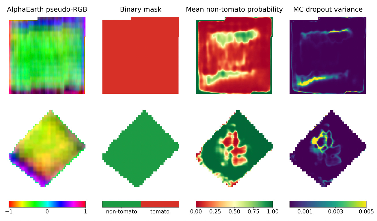
The old school way of doing crop mapping using machine learning involved a bunch of time spent on feature engineering. You’d have to manually clean optical satellite data, mask clouds, and calculate stuff like NDVI over a growing season. To save the pain of all this, a new study explores whether we can skip the manual preprocessing entirely by using Google DeepMind’s AlphaEarth geospatial foundation model embeddings. Instead of raw spectral bands, AlphaEarth provides analysis-ready, annual 64-band “embeddings” (I did a deep dive explainer on this here).
To test this approach, researchers focused on mapping processing tomatoes across California. They extracted AlphaEarth embedding chips for 9,484 agricultural fields (split evenly between tomato and diverse non-tomato crops based on LandIQ 2018 records) and trained a U-Net deep learning segmentation model. On a spatially independent test set of 1,424 fields, the model achieved an exceptional 99.19% pixel accuracy and a 98.11% intersection over union (IoU), cleanly tracing tomato field boundaries with minimal confusion against visually similar annual crops.
The team also used Monte Carlo dropout during inference to map predictive uncertainty. By running each field chip through the model 100 times, they found that uncertainty was consistently quite low within the interiors of well-defined fields and spiked around borders, irregular edges, and mixed margins. This provides a practical safeguard, flagging ambiguous boundary pixels where human review might be needed. While the study relies on reference data from a single year (2018), it shows how foundation model embeddings can be used as an operational alternative to manual feature engineering for field-scale crop mapping.
3. Generating alternative urban streetscapes with diffusion models
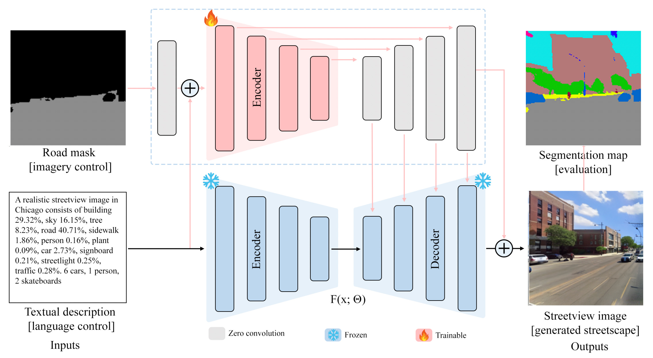
While street-view imagery is pretty commonly used by urban planners to measure and evaluate existing built environments, such as calculating greenery, sky, or building view indices, these observational tools can’t generate alternative or non-existing urban scenarios. To address this, a new paper introduces a controllable generative AI framework that combines realistic, alternative streetscapes conditioned on targeted visual metrics and text descriptions. Using a curated multimodal dataset of 32,000 images from Chicago and Orlando, the researchers aligned street-view imagery with text descriptions, object counts, and semantic segmentation maps (specifically road masks) to allow for fine-grained manipulation of urban scenes. By fine-tuning Stable Diffusion and ControlNet models, the framework directly translates abstract planning intentions, such as increasing tree canopy coverage while preserving existing road geometry, into concrete visual street environments.
The results demonstrate that incorporating imagery controls via ControlNet significantly improves both visual realism and semantic consistency compared to text-only diffusion baselines. Using explicit road segmentation masks reduced perceptual dissimilarity (LPIPS) by approximately 6% and boosted overall semantic alignment (mIoU) by 23.7% in Orlando and 46.4% in high-density Chicago. The framework also supports complex, multi-element trade-off scenarios; when language prompts instructed the model to increase tree canopy coverage while reducing sky or building proportions, the generated greenery naturally expanded along sidewalks and foregrounds without encroaching on roadways or distorting building geometry.
Interestingly, when text prompts and visual road masks were intentionally set to conflict, the imagery controls exerted a dominant influence over the generated streetscape. Even when language prompts requested a six-fold variation in road proportions (from 5.71% to 35.71%), the generated streetscapes strictly adhered to the geometry and layout of the input road mask. This reveals a clear control hierarchy where spatial masks anchor the geometric backbone of a scene, while text prompts provide high-level compositional guidance when masks aren’t available.
4. Benchmarking distributional shift in Earth observation
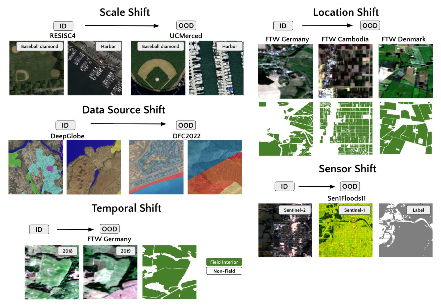
Current satellite machine learning models can be brittle when deployed in out-of-distribution contexts (e.g. new geographies, time periods, or sensors, etc.). However, most benchmarks only test generalisation to new samples drawn from the same in-distribution training set. This leaves a bit of a blind spot for deploying geospatial models in real-world scenarios. To address this, researchers introduce EarthShift, a public testbed for benchmarking distributional robustness across five common natural remote sensing shifts: spatial scale, time, geographic location, sensor modality, and data source. The benchmark pairs established datasets across 11 tasks (e.g. shifting from Sentinel-2 to Sentinel-1 for flood mapping, or testing across countries with vastly different field structures).
To avoid conflating model capability with robustness, EarthShift uses an “effective robustness” metric. Rather than just ranking models by out of distribution performance, effective robustness measures an architecture’s out of distribution performance relative to a baseline predicted by its ID capability. The team evaluated 13 models, including 8 specialized geospatial foundation models (GFMs), generic vision foundation models (VFMs), and standard fully-supervised architectures; across 10,000 experiments. The results actually show that across all architectures and training setups, models suffer an average 15-20% drop in performance when encountering real-world distribution shifts. While models were surprisingly resilient to temporal shifts (such as season-to-season agricultural changes), they degraded severely under sensor and geographic shifts.
Most surprisingly, domain-specific pre-training on Earth observation archives provided no distributional robustness advantage over generic vision models pretrained on ImageNet, or even over randomly initialised fully-supervised models. In fact, generic ImageNet-pretrained ResNet-50 architectures frequently proved to be the most distributionally robust models tested. Full fine-tuning of model encoders often failed to improve, and sometimes even worsened, effective robustness compared to simply freezing the pre-trained backbone…
Geospatial Datasets
1. Earth system foundation model dataset
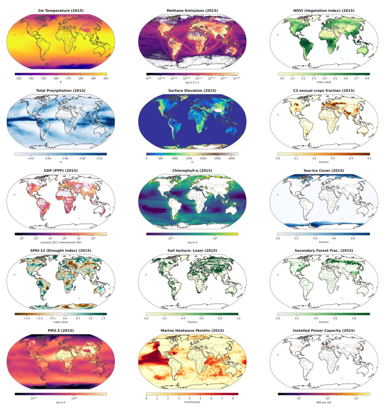
The WorldTensor dataset harmonises hundreds of global environmental and socioeconomic variables onto a standardised 0.25-degree spatial grid and an annual temporal framework spanning 1900 to 2025. Access the data here and the code here.
2. Bias-corrected high-resolution climate dataset
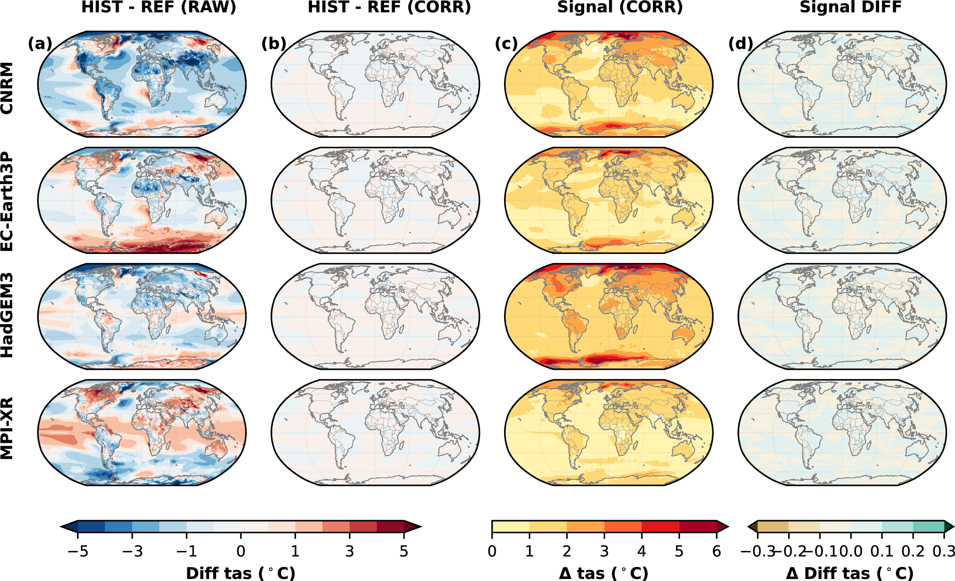
The BC-HiRMIP dataset provides globally bias-adjusted climate projections derived from four HighResMIP models at a 0.5° spatial and daily temporal resolution, spanning from 1979 to 2050. Access the data here and the code here.
3. Upper reach transboundary river hydrological dataset
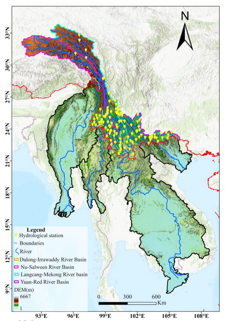
The Mainland Southeast Asia International River Upper Reach Hydrological Dataset (MSAIRHD) compiles historical daily streamflow, sediment concentration, and water level records across 119 monitoring stations in the upper reaches of the Irrawaddy, Salween, Mekong, and Red River basins from 1958 to 1987. You can access the data here and the code here.
4. Remote sensing traffic object segmentation dataset
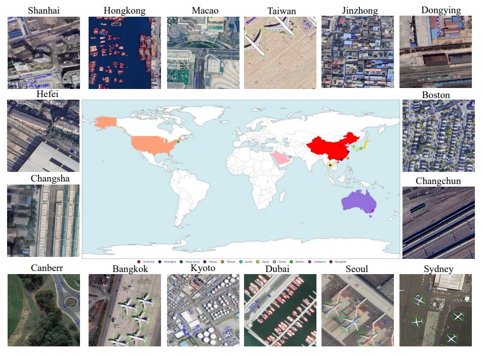
The NWPU-Traffic dataset provides an optical remote sensing collection containing 1,479 high-resolution images and 31,628 instance-level annotated targets across four major transportation categories: cars, airplanes, ships, and trains. Access the data and code here.
Other useful bits
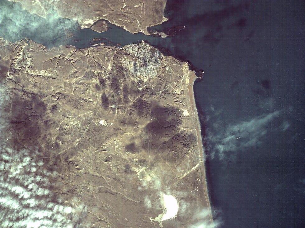
NASA’s Jet Propulsion Laboratory has completed the first in-orbit test of an untuned vision-language model, running Google’s Gemma 3 on a satellite. By analysing imagery onboard to generate text descriptions, the system bypasses bandwidth limits by downlinking brief summaries rather than massive raw image files.
A machine learning study used Google Maps Platform’s Places Insights dataset in BigQuery to account for nearly 86% of home value variation across census tracts in Austin, Texas. The analysis revealed that the quality of nearby commercial amenities (gyms, spas, cafes, etc) served as a primary positive predictor of residential property values, whereas industrial sites like storage facilities and auto-repair corridors significantly depressed local valuations.
The US Federal Communications Commission has introduced new regulations requiring satellite operators to share real-time location data to mitigate collision risks in increasingly congested orbits. The move has reignited a jurisdictional dispute with US lawmakers who argue that authority over space safety and traffic management should reside with the Department of Commerce.
Jobs
UFZ is looking for an Environmental Computer Scientist in Leipzig, Germany
The Allen Institute is looking for a Senior Software Engineer (AI For Planet) in Seattle, US.
The World Bank is looking for an Extended Term Consultant (Associate Geospatial Platform Engineer) in Washington DC, US.
Just for Fun
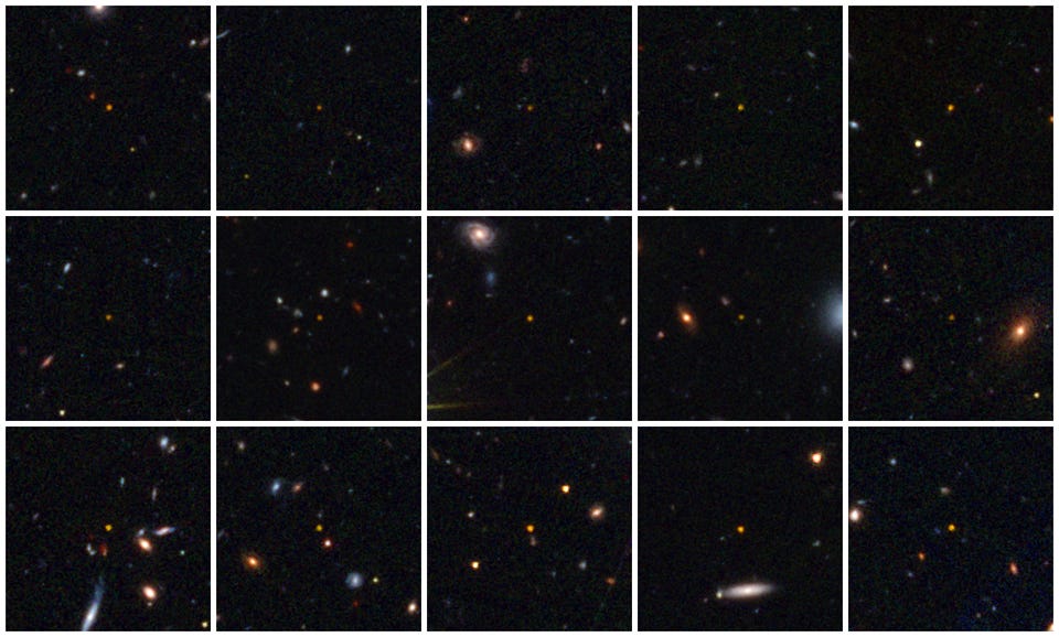
ESA’s Euclid space telescope has discovered 31 of the most ancient quasars ever found, including two dating back to when the cosmos was just 670 million years old, setting a new cosmic record and more than doubling the known population of these ultra-early supermassive black holes.
That’s it for this week.
I’m always keen to hear from you, so please let me know if you have:
new geospatial datasets
newly published papers
geospatial job opportunities
and I’ll do my best to showcase them here.
Yohan