

🌐 Turns out planting trees isn’t always a climate win
PLUS: Some new insights on global vegetation loss, and a smarter way to map crops

Hey guys, here’s this week’s edition of the Spatial Edge — a newsletter that’s almost as niche as GeoDA. In any case, the aim is to make you a better geospatial data scientist in less than five minutes a week.
In today’s newsletter:
Forest Warming: Albedo effects can cancel out carbon storage.
Vegetation Loss: New system tracks global land changes daily.
Crop Mapping: AI models use rotation logic for better accuracy.
Mapping Favelas: Specialized satellite AI outperforms generic models.
New Google Tools: AI models map deforestation and identify wildlife.
Research you should know about
1. We’re miscalculating the value of forests

It’s easy to view planting trees as a guaranteed win for the climate because they suck up carbon. But a new study in Nature Communications reveals a blind spot in the Voluntary Carbon Market regarding surface albedo. When we plant dark forests over lighter landscapes like snowy fields or grasslands, the land absorbs more sunlight and heats up. This effect can reduce or even cancel out the cooling benefits of the carbon sequestration. The researchers analysed 172 existing reforestation projects to see if our current accounting methods are actually adding up.
The results are pretty crazy. They found that for over 10% of the projects analysed, the warming caused by the albedo effect entirely negates the climate benefits of the carbon storage. In other words, these projects might actually be warming the planet rather than cooling it. Furthermore, about a quarter of the projects occur in locations where albedo changes wipe out at least half of the mitigation benefit. It isn’t all bad news though. The study found that 9% of projects, mostly in tropical and subtropical areas, actually boost climate mitigation because the new vegetation reflects more sunlight than what was there before.
Right now, carbon market protocols generally ignore these biophysical factors. To fix this, the authors propose a tiered framework for integrating albedo into carbon accounting. This ranges from simple project planning adjustments to strict ineligibility thresholds for sites where the albedo penalty is too high. If we implemented a rule where projects losing more than 50% of their benefit to albedo were ineligible, we would significantly improve the integrity of the market. This approach ensures we prioritise projects that deliver real cooling outcomes rather than just counting trees.
You can access the code here.
2. Some new insights on global vegetation loss

We often struggle to track land cover changes in real time due to cloud cover and long gaps between satellite passes. A new system called DIST-ALERT aims to solve this by leveraging the Harmonized Landsat Sentinel-2 (HLS) dataset. This combines data from NASA and USGS Landsat 8/9 with ESA Sentinel-2 satellites to create a unified 30-metre resolution time series. By blending these sources, the system achieves a revisit rate of just 1 to 4 days globally. It works by comparing every new pixel observation against a rolling baseline of the previous three years within a 31-day seasonal window. This allows the system to flag anomalies almost immediately, detecting everything from logging and mining to insect damage and landslides without waiting for annual composites.
The data from 2023 reveals the massive scale of these shifts:
Direct human activities, such as agricultural expansion and urbanisation, converted 28.6 million hectares (Mha) of land in a single year.
Fires that resulted in permanent land cover conversion accounted for an additional 14.9 Mha.
When combined, these dynamics impacted approximately 0.3% of the global land surface, which is roughly equivalent to the entire area of California. It’s also interesting to see that natural variations, such as drought and green-up events, actually constituted the largest share of change, representing more than two-thirds of all identified anomalies (1371 Mha).
To capture these changes accurately, DIST-ALERT employs two parallel algorithms.
To map vegetation cover for every observation and flags losses relative to the baseline minimum
To identify generic spectral anomalies where reflectance falls outside typical historical distributions.
This dual approach proves pretty effective, with validation results showing that high-confidence vegetation loss alerts achieved a user accuracy of 94.2%. While the system captures forest loss and agricultural shifts with high precision, it’s naturally less sensitive to changes in urban environments where structural damage might not significantly alter the spectral signal at a 30-metre resolution.
You can access the code here.
3. A smarter way to map crops over time

It’s now kind of standard practice to use deep learning to classify crop types from satellite imagery, but these models often treat each year as an isolated event. That’s a bit of an oversight because agriculture follows specific rules. Farmers rarely plant crops at random. Instead, they follow rotation cycles where one crop naturally follows another to maintain soil health. A new study from the University of Trento tackles this limitation by combining Deep Learning with Bayesian modelling to capture these long-term patterns.
The researchers propose a ‘cascade classification’ approach that mixes two distinct methods. First, they use a Transformer Encoder to analyse the raw spectral data from Sentinel-2 images. Then, they layer a Hidden Markov Model (HMM) on top of that. The HMM acts as a logic check by calculating the probability of one crop type following another. It essentially looks at the sequence of labels to ensure the transition from year to year makes agronomic sense rather than just guessing based on the spectral signature of a single season.
They tested this setup on a massive dataset in Austria covering 47 different crop types over six years. The results showed that adding the HMM layer boosted accuracy pretty clearly compared to using the Transformer model on its own. By enforcing temporal consistency, the model avoided making unlikely predictions for crop rotations. This suggests that future mapping efforts need to look at the full timeline of the land to get the best results.
4. Turns out bigger isn’t always better for mapping model

Mapping informal settlements like Rio de Janeiro’s favelas can be a massive headache because they develop so rapidly and unpredictably. Traditional field surveys are far too slow and older automated techniques usually require complex manual tweaking. That’s why researchers are increasingly turning to deep learning to do the heavy lifting. A new study investigates whether it’s better to use massive, general-purpose AI models or ones built specifically for satellite imagery to spot these areas.
The team compared two distinct approaches using data from Rio. They tested generic networks trained on huge internet databases like ImageNet which contain millions of everyday photos. They pitched these against CROMA, a Remote Sensing Foundation Model (RSFM) trained on a smaller but more relevant set of satellite images (if you’re wondering what a foundation model is, then check this out). They divided the city into 150m grids and fed these into the models to see which could better distinguish favelas from formal city structures.
The results were pretty clear. The satellite-specific model, CROMA, beat the generic ones with an F1-score of 0.81 compared to 0.72. It turns out that specific training on aerial views is more valuable than simply having a massive volume of training data. This is a promising sign for using these specialised foundation models to map informal settlements globally since they handle the unique textures and patterns of satellite imagery much better than models trained on standard photos.
Geospatial Datasets
1. Particle number concentrations map

This new global dataset provides the first 1-km resolution maps of particle number concentrations (PNC) and ultrafine particles (UFPs) worldwide, covering annual averages from 2010–2019. You can access the data here and the code here.
2. Global natural forest map

This 10 m resolution natural forest map for 2020 offers a high-quality baseline for monitoring deforestation and degradation across tropical, temperate, and boreal regions.
3. Gridded combustible mass estimates
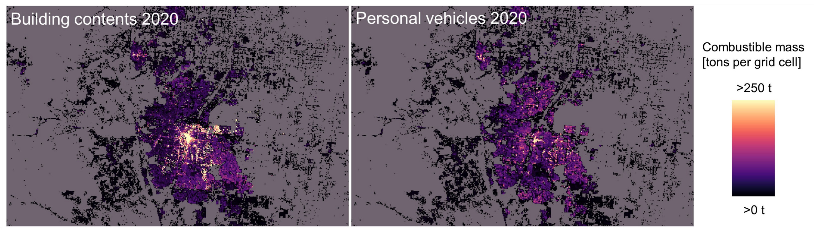
COMBUST provides a first-of-its-kind, gridded estimate of the combustible mass of the built environment across the conterminous United States from 1975–2020, mapped at 250 m resolution. The dataset includes historical backcasts, material-specific layers, and a companion product (COMBUST Plus) for analysing exposure of buildings, population, and biomass. You can access the data here.
Other useful bits

Google is rolling out new AI tools to help protect nature, including a high-resolution deforestation risk model, large-scale species range mapping using graph neural networks, and an upgraded bioacoustics model, Perch 2.0, for identifying wildlife from sound.

Europe’s new Copernicus Sentinel-4 mission has released its first images, providing hourly, continent-wide views of key air pollutants from a geostationary orbit. These early results already show clear hotspots of NO₂, ozone, and SO₂, a major step toward faster, more precise air-quality forecasts and health warnings across Europe.

The World Bank’s latest subnational poverty data reveals pretty big contrasts within countries, showing clear “movers” where poverty has fallen and “stayers” where it has barely shifted. By pairing poverty rates with new prosperity gap measures, the update highlights how far households are from secure, middle-class living standards.


Jobs
WorldPop is looking for a Research Fellow in Evaluation and Impact, based in the UK.
Save the Children is looking for a GIS specialist in Nigeria.
The Rainforest Alliance is looking for a Senior Associate in Deforestation Risk Monitoring in Cameroon.
Just for Fun

Google is exploring space-based AI data centres. They’re proposing constellations of solar-powered satellites that could run AI models using abundant orbital energy while reducing pressure on land and water resources on Earth. Under Project Suncatcher, the first prototypes are planned for 2027.
That’s it for this week.
I’m always keen to hear from you, so please let me know if you have:
new geospatial datasets
newly published papers
geospatial job opportunities
and I’ll do my best to showcase them here.
Yohan