

🌐 How reliable are Landsat and Sentinel vegetation estimates?
PLUS: the surprising limits of flood infrastructure, the hidden costs of droughts, and more.

Hey guys, here’s this week’s edition of the Spatial Edge — a newsletter that I’m told will make you the Ja Rule of the geospatial space. In any case, the aim is to make you a better geospatial data scientist in less than five minutes a week.
In today’s newsletter:
Satellite Validation: Landsat vs Sentinel-2 vegetation measurements compared.
Flood Infrastructure: Wealth doesn't guarantee extreme flood protection.
Aircraft Detection: Super-resolution boosts tiny object detection in Sentinel-2.
Drought Impacts: Power shifts during droughts worsen air pollution.
New Datasets: Irrigation mapping and biodiversity databases.

First up, if any of you will be at the Living Planet Symposium next week in Vienna, hit me up on X or by hitting reply here. It would be great to meet you IRL.
On to the newsletter…
Research you should know about
1. Validating Landsat and Sentinel: what 11,000 ground measurements show
If you've ever worked with satellite data to monitor vegetation, you've probably wondered whether measurements from different satellites are actually comparable. In fact, this is something I cover a lot in this newsletter (see here and here).
A new study in ISPRS Journal of Photogrammetry and Remote Sensing also examines this question by comparing how well Landsat-8/9 and Sentinel-2 measure three key vegetation variables: (1) leaf area index (LAI), (2) vegetation cover fraction (fCOVER), and (3) the fraction of absorbed photosynthetically active radiation (fAPAR).
The big question: Can we mix and match data from these satellites?
This is kinda important because if you want to track vegetation changes over time, you often need to combine data from multiple satellites to get enough temporal coverage. The researchers used a massive dataset of ground measurements from 57 sites across North America.
Key findings:
For vegetation cover (fCOVER) and light absorption (fAPAR), both satellites perform almost identically. They're both unbiased with uncertainties around 13%, which is pretty decent for satellite measurements. You can basically use them interchangeably for these variables.
LAI measurements show bigger differences between the satellites, especially over forests. Sentinel-2 consistently gives higher LAI values than Landsat for dense forests (sometimes by as much as 35%). The researchers reckon this is because Sentinel-2 has those red-edge bands that Landsat lacks.
The stability surprise
One of the most interesting findings is about temporal stability. I.e. how consistent the measurements are over time. Both satellites showed remarkable stability, with bias changes of less than 0.02 per year for fCOVER and fAPAR. For context, that means you could detect changes of just 0.2 in vegetation cover over a decade.
Some weird details:
Sites with lots of moss cover (like Alaskan tundra) showed consistent biases because the ground measurements couldn't properly account for moss. The researchers had to apply a correction factor to deal with this.
Really tall forests (over 19 metres) needed special (manual) processing because standard methods underestimated how much woody material was in the canopy.
2. The surprising limits of flood infrastructure

Cities have been trying to flood-proof themselves for decades, spending billions on drainage systems, pumps, and flood barriers. But a new study in Nature Communications reveals something pretty uncomfortable: when it comes to extreme rainfall events, economic development might not be the shield we thought it was.
Researchers analysed flood risks across 138 capital cities and found a striking pattern. Under normal heavy rainfall (10-year return periods), wealthy cities significantly outperform poorer ones. But when rainfall cranks up to extreme levels (100-year return periods), that advantage largely disappears. Once precipitation exceeds 200mm per day, adding more drainage doesn't significantly reduce flooding.
Green spaces become the heroes
I was interested to see that ‘green infrastructure’ (i.e. parks, wetlands, green roofs) doesn't correlate with economic development. Rich and poor cities have somewhat similar green space: 35.77% versus 29.71%.
Under normal rainfall, green spaces are a bit less important. But during extreme events, they become the most significant factor in flood reduction. A 1% increase in green space reduces flooding by just 0.02-0.03% under normal rainfall, but cuts it by 0.16% during extreme events.
Geography matters more than expected
Topography doesn't correlate with economic development, but it's pretty important for cities with limited infrastructure. In low- and middle-income countries, topographic relief often dominates flood drainage.
Every 10-metre increase in topographic relief reduces flooding by 0.41% during extreme rainfall. Cities with elevation changes naturally channel water to low-lying areas, giving many developing capitals a hidden advantage.
The implications
For high-income countries, building more drainage might be hitting diminishing returns. Green infrastructure and natural topography could be more effective for extreme events.
For developing countries, this suggests focusing on nature-based solutions rather than replicating expensive grey infrastructure. Green infrastructure is cheaper and performs best under extreme conditions.
3. Super-res as a low-cost pipeline for tiny object detection

Detecting tiny objects like aircraft in freely available satellite imagery has always been a proper challenge. Sentinel-2 gives us brilliant spectral data covering the whole planet, but its coarse resolution makes spotting small things pretty tricky.
A new study from the folks at Tracasa, Joanneum Research and Space Research Centre of the Polish Academy of Science, shows how super-resolution can help us squeeze much more detail out of sentinel-2 data.
The researchers tackled aircraft detection using a two-step approach:
they used deep learning to increase Sentinel-2's resolution from 10m down to 2.5m
They combined two different detection methods: a standard YOLO object detector (great for speed) and a vision transformer that estimates object density (good for avoiding false positives).
The results are pretty compelling. Their fusion method decreased false positives by 62% (from 487 to 186) whilst only losing 5% of true detections. Precision jumped from 51% to 72%.
The study used a dataset of 5,378 aircraft across 118 locations, ranging from tiny fighters (around 12m long) to massive cargo planes (50m+). Unsurprisingly, the method works best on medium to large aircraft, where precision improvements were most significant. Extra-small objects remain challenging, as both methods only detected 3 out of 78 tiny aircraft.
This goes to show that with a bit of super-res and smart post-processing, Sentinel-2 images can continue to deliver.
4. Air quality and health as hidden costs of drought

A new study published in Nature Communications shows how droughts are worsening air quality in Latin America and the Caribbean by shifting how electricity is generated.
The region relies massively on hydropower, but when droughts reduce water levels, power systems turn to combustion plants burning coal, gas, oil, or biomass. These plants emit fine particulate matter (PM2.5), one of the most dangerous pollutants for human health. Using 20 years of plant-level data, the authors estimate that PM2.5 levels increase by 0.83 micrograms per cubic metre on average during droughts, with much higher spikes in severe cases.
This extra pollution has real health costs. The study estimates that drought-driven power shifts cause 3,700 to 10,600 premature deaths per year. Smaller oil and biomass plants are the biggest contributors, since large coal and gas plants usually operate near full capacity regardless. The burden also falls hardest on poorer communities living near these plants, deepening existing inequalities. And it’s likely to get worse. As droughts become more frequent and intense under most climate scenarios, the health impacts of this shift in electricity generation could persist for decades.
Expanding renewables alone won’t solve the problem if fossil fuel plants remain the backup during droughts. Instead, policies need to focus on retiring small combustion plants, building more energy storage, and improving cross-border electricity trade to avoid relying on dirty backup power. Without these steps, the link between drought and air pollution will remain a pretty massive public health risk.
You can access the data and code here.
Geospatial Datasets
1. Irrigation method mapping dataset
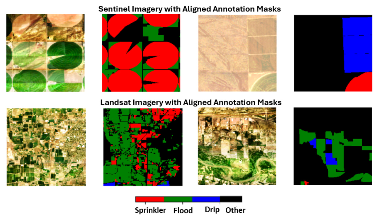
IrrMap is the first large-scale, ML-ready dataset (1.1 million patches) designed to map irrigation methods (e.g. drip, sprinkler, and flood) across 14 million acres in the western U.S. You can access the code and models here.
2. Multi-model geospatial dataset

Core-five is a massive 12 TB+ dataset for training geospatial foundation models at global scale. It synchronises high-res (25 cm), Sentinel-1, Sentinel-2, Landsat-8, and MODIS imagery into a unified Data-Tree structure. You can access the data here.
3. Daily surface agrometeorological data

AgERA5 offers daily surface meteorological data from 1979 to present, tailored for agricultural and agro-ecological modelling. It’s derived from hourly ERA5 reanalysis data, and is preprocessed to local time zones and corrected to a 0.1° resolution.
4. Global biodiversity time-series database

BioTIME is the largest biodiversity time-series dataset ever assembled, now updated to include 12+ million records covering 56,000+ species from land, freshwater, and ocean ecosystems. It spans nearly 150 years and all continents. You can explore the data here.
Other useful bits
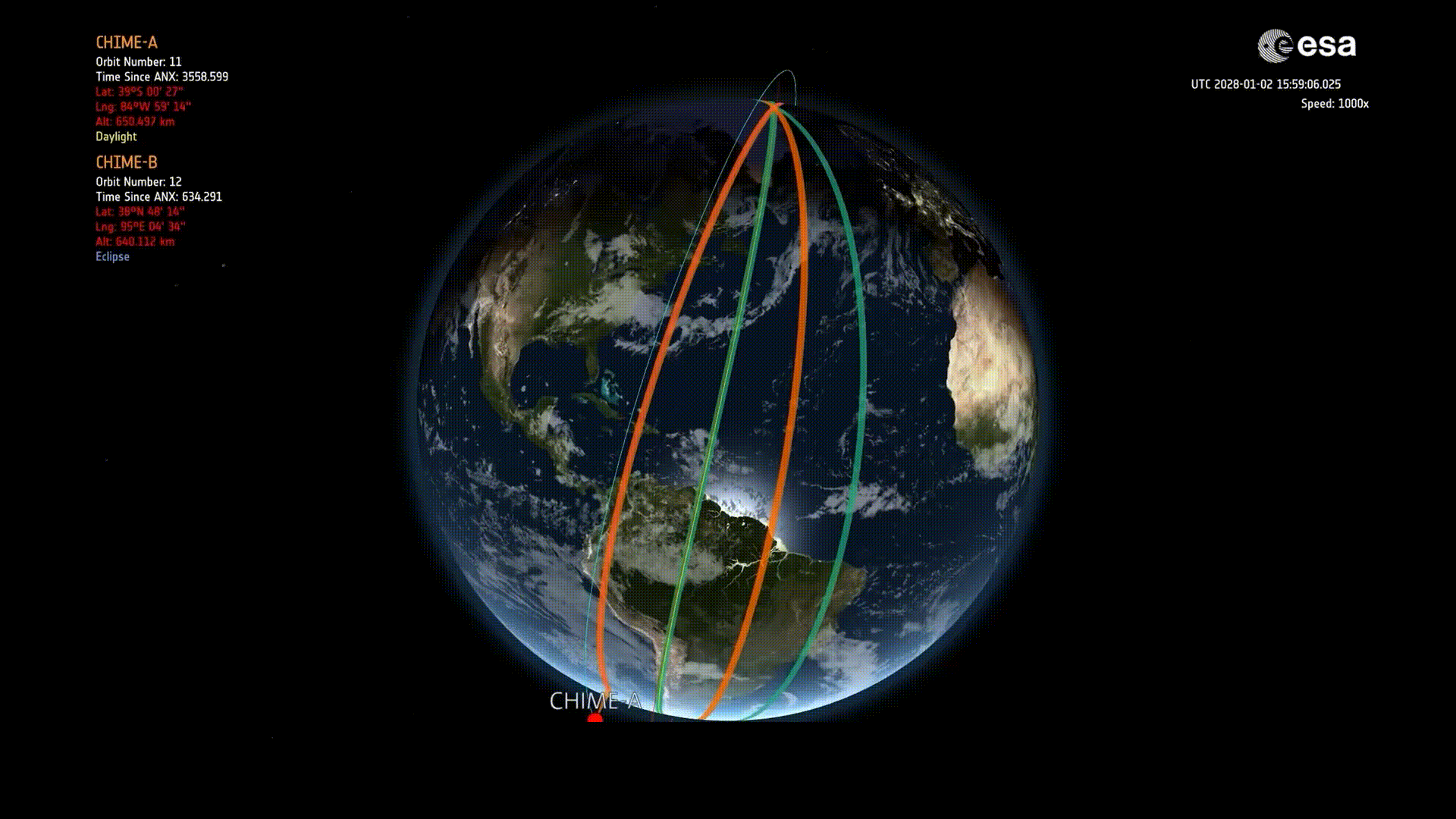
ESA’s CHIME hyperspectral satellite has been announced and is set to reshape how we monitor land, water, and ecosystems. It’ll cover over 200 spectral bands, CHIME and deliver detailed insights on crops, forests, minerals, and water quality. It’ll launch in the coming years.
Planet Labs just mapped crop types across 51 million fields in Europe using Sentinel-2 imagery, open datasets, and their own AI platform. Their transformer-based model identified 28 crop classes and hit 88% accuracy on unseen data from 2022.
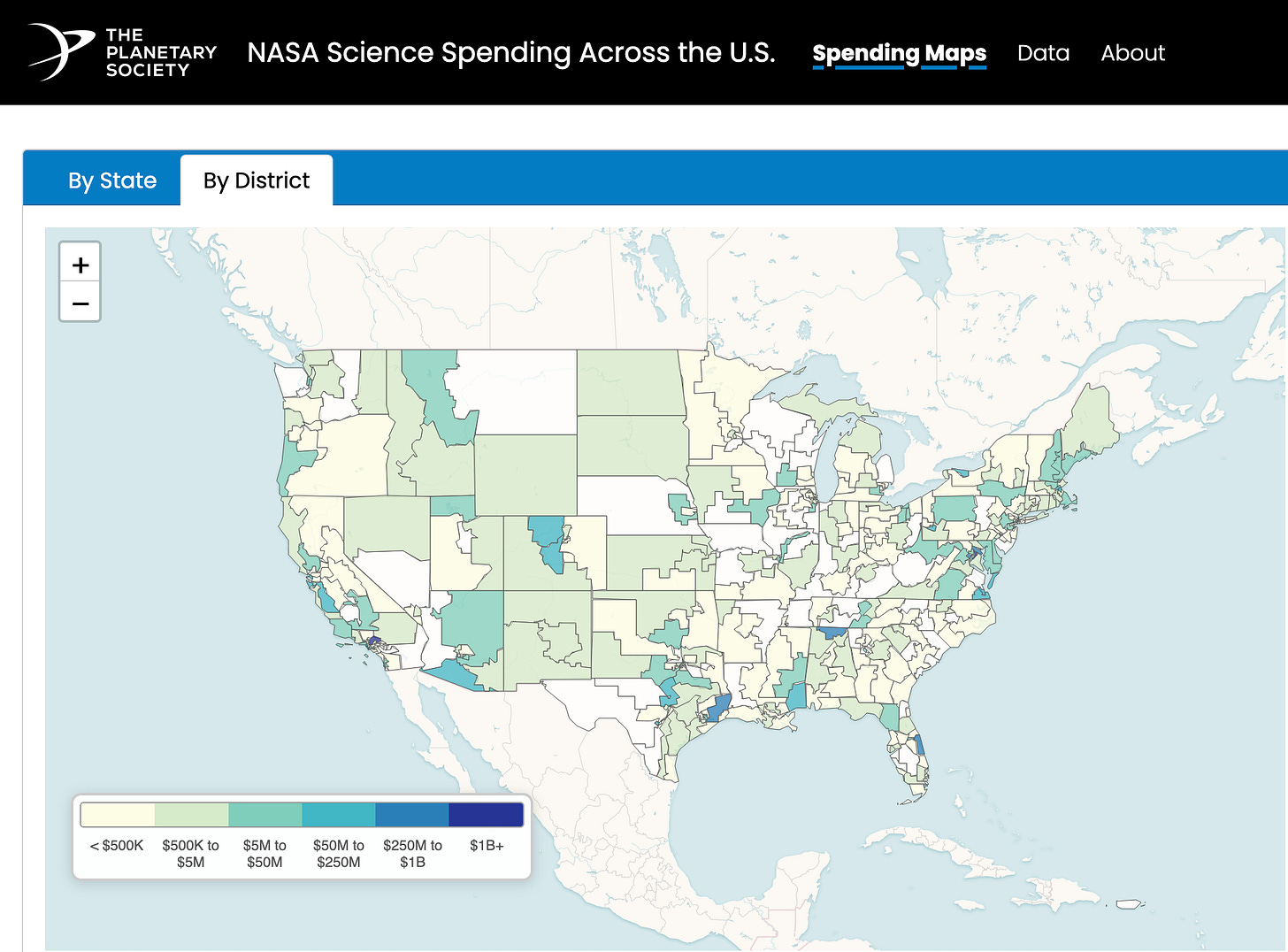
Planetary Science just released a new dashboard showing how NASA’s science funding boosts the economy in every U.S. state and congressional district. It breaks down contracts, grants, and key players; plus flags what could be lost if proposed budget cuts go through.
Rocket Lab successfully launched a new Earth-observing satellite for BlackSky on 2 June. The "Full Stream Ahead" mission lifted off from New Zealand, placing a Gen-3 satellite into a 470 km orbit. It's the second of four planned launches this year for BlackSky and marks Rocket Lab’s 10th satellite launch for the company.

Jobs
Development Seed is looking for a Geospatial Data Architect based in one of the ESA member states.
Mapbox is looking for a Software Development Engineer for Location AI based in the US.
Wildlife Conservation Society (WCS) is looking for a British Columbia Ecosystem Key Biodiversity Areas Analyst based in Canada.
Sylvera is looking for a Remote Sensing Scientist to join their Earth Analytics team based in London.
UNOPS is looking for multiple remote GIS and AI Solutions Specialists under their Peace and Security Cluster (PSC).
Earthworks is looking for a Data Analyst to join their Energy team based in the US.
Novaspace is looking for a Space Economy Consultant who will be based in Brussels, Munich, or Paris.
Esri is looking for a Solution Engineer for Natural Resources based in Texas.
Planet is looking for a Software Engineer under their Defense and Intelligence pod based in the US.
Just for Fun

To celebrate its 50th anniversary, ESA put its original 1975 founding Convention online in the SHIP database. They also uploaded a 69-page Final Act that covers all the background and decisions from the conference that started it all. They even kept a little page-numbering error from the original (kinda cool that they left it in).
That’s it for this week.
I’m always keen to hear from you, so please let me know if you have:
new geospatial datasets
newly published papers
geospatial job opportunities
and I’ll do my best to showcase them here.
Yohan